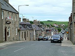
Aberchirder
|
Aberchirder Scottish Gaelic Obar Chiardair |
||
|---|---|---|
| Main street of Aberchirder | ||
| Coordinates | 57 ° 34 ′ N , 2 ° 37 ′ W | |
|
|
||
| Residents | 1237 2011 census | |
| administration | ||
| Post town | HUNTLY | |
| ZIP code section | AB54 | |
| prefix | 01466 | |
| Part of the country | Scotland | |
| Council area | Aberdeenshire | |
| British Parliament | Banff and Buchan | |
| Scottish Parliament | Banffshire and Buchan Coast | |
Aberchirder ( Gaelic : Obar Chiardair ) is a village in the Scottish Council Area Aberdeenshire . It is located around 15 kilometers southwest of Banff and northeast of Huntly . The nearest town is four kilometers southwest on Deveron located Marnoch . Aberchirder lies on the Burn of Auchintoul brook and is directly connected to the trunk road network by the A97 (Banff– Dinnet ). The village does not have its own train station.
history
The Thorax stone circle is located on the farm of the same name on Culvie Hill, northwest of Aberchirder.
Aberchirder was built in 1764 as a planned settlement by Alexander Gordon of Auchintoul , which can still be seen today from the regular course of the street. To the south is the Tower House Kinnairdy Castle , the oldest parts of which date from the early 15th century. It was owned by the Innes clan . The building is now listed as a monument of the highest category A.
In 1881 there were 1,358 inhabitants in Aberchirder. While the population had dropped to 754 by 1961, it rose steadily until 2011 to 1237.
Individual evidence
- ^ List of Gaelic expressions
- ^ Entry in the Gazetteer for Scotland
- ↑ Listed Building - Entry . In: Historic Scotland .
- ^ Information in the Gazetteer for Scotland
- ↑ 2011 census

