
A97 road
| A97 road in the UK | |

|
|
| map | |
 |
|
| Basic data | |
| Operator: | Transport Scotland |
| Start of the street: |
Banff ( 57 ° 40 ′ N , 2 ° 31 ′ W ) |
| End of street: |
Dinnet ( 57 ° 5 ′ N , 2 ° 54 ′ W ) |
| Overall length: | 91 km (56.5 mi ) |
 |
|
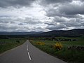
| The A97 on the edge of the Cairngorms | |
|
Course of the road
|
|
The A97 is a trunk road in Scotland . It begins on the southern edge of Banff and ends on the A93 in Dinnet .
course
The A97 branches off from the A98 on the southern edge of Banff . It initially runs in a south-westerly direction through a sparsely populated region of Aberdeenshire . After about 13 km you will reach Aberchirder, the first notable town. Further south, the A97 crosses the Deveron , the course of which it followed for the first few kilometers. Continuing in a south-westerly direction, it finally reaches the A96 and is led along with it for a short distance. It runs through the center of Huntly and then follows the course of the Bogie southwards , which it crosses beyond Rhynie . At Glenkindie , the A97 follows the course of the Don in a wide loop and finally crosses it. From there, running in a south-southeast direction, the road passes a few more hamlets before it finally joins the A93 in Dinnet after a total of 91 km. With the exception of a short stretch beyond the crossing of the Deveron, which runs through Moray , the A97 runs exclusively in Aberdeenshire.
Route to Logie Coldstone

Junction of the A944

Gordon Square in Huntly


