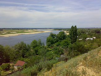
Akhtuba
|
Akhtuba Ахтуба |
||
|
Location of the Akhtuba in the catchment area of the Volga |
||
| Data | ||
| Water code | RU : 11010002312012100011441 | |
| location | Volgograd Oblast , Astrakhan Oblast ( Russia ) | |
| River system | Volga | |
| source | from the Volga near Wolschski 48 ° 46 ′ 0 ″ N , 44 ° 38 ′ 58 ″ E |
|
| muzzle | at Volodarsky in the Busan coordinates: 46 ° 43 ′ 20 " N , 48 ° 0 ′ 14" E 46 ° 43 ′ 20 " N , 48 ° 0 ′ 14" E
|
|
| length | 537 km | |
| Drain |
MQ |
153 m³ / s |
|
Akhtuba with Wolschski |
||
The Akhtuba ( Russian Ахтуба of Kazakh Ак-тюбе for "White Hill") is 537 km long, the longest estuary of the Volga River in southern Russia .
At Wolschski it branches off to the left of the Volga and runs (northeast) parallel to the main river, before it flows into the Busan , another branch of the Volga estuary, at Wolodarski , which leads to the Caspian Sea . The Akhtuba is part of the Volga Delta , large parts of which are under nature protection.
The largest city on the Akhtuba is Wolschski .
literature
- Akhtuba . In: Энциклопедический словарь Брокгауза и Ефрона - Enziklopeditscheski slowar Brokgausa i Jefrona . tape 2 a [4]: Ауто – Банки. Brockhaus-Efron, Saint Petersburg 1891, p. 539-540 (Russian, full text [ Wikisource ] PDF ).
- Evgeny Pospelow: Geografitscheskie naswanija Rossii. AST, 2008, ISBN 978-5-17-054966-5 , p. 88. (Russian)
Web links
Commons : Achtuba - collection of pictures, videos and audio files


