
Adelaide River (Van Diemen Gulf)
| Adelaide River | ||
 |
||
| Data | ||
| location | Northern Territory ( Australia ) | |
| River system | Adelaide River | |
| source | Mount Smith (east of Litchfield National Park ) 13 ° 18 ′ 1 ″ S , 130 ° 57 ′ 52 ″ E |
|
| Source height | 149 m | |
| muzzle |
Van Diemen Gulf ( Timor Sea ) northeast of Darwin Coordinates: 12 ° 13 ′ 22 " S , 131 ° 14 ′ 53" E 12 ° 13 ′ 22 " S , 131 ° 14 ′ 53" E |
|
| Mouth height | 0 m | |
| Height difference | 149 m | |
| Bottom slope | 0.83 ‰ | |
| length | 180 km | |
| Catchment area | 7640 km² | |
| Left tributaries | Adelaide River West Branch, Coomalie Creek, Otto Creek, Manton River | |
| Right tributaries | Burrells Creek, Margaret River , Marrakai Creek, Wilshire Creek | |
| Communities | Adelaide River , Middle Point, Mount Bundey | |
| Navigable | 130 km | |
The Adelaide River is a river in the northwest of the Northern Australian Territory . It flows into Adam Bay on the Van Diemen Gulf about 40 kilometers northeast of the territorial capital Darwin .
geography
River course
It rises on the western slopes of Mount Smith , west of Brooks Creek and east of Litchfield National Park , and flows for 180 km northeast to Adams Bay , a bay on the Timor Sea in Djukbinj National Park , around 50 km northeast of Darwin . From its mouth it is navigable for 130 km.
At the point where the Stuart Highway and the Central Australian Railway , and earlier the North Australia Railway , cross and crossed the river, is the place of the same name Adelaide River .
Tributaries with mouth heights
- Adelaide River (West Branch) - 64 m
- Burrells Creek - 36 m
- Coomalie Creek - 23 m
- Otto Creek - 13 m
- Margaret River - 12 m
- Manton River - 9 m
- Marrakai Creek - 8 m
- Wilshire Creek - 0 m
history
Lewis Roper Fitzmaurice was the first European to reach the river on board the ship HMS Beagle and named it after the British Queen Dowager Adelaide . It was explored by John McDouall Stuart in 1892 and earlier by Frederick Henry Litchfield , the first settlement on its shores was Escape Cliffs (1864-1867). Since the 1890s, the black soils along the Adelaide River have repeatedly been the subject of agricultural experiments such as cattle breeding, vegetable and rice cultivation.
Attractions
The Adelaide River is mainly known to tourists for its jumping crocodiles . Pieces of meat are held over the water on a fishing rod from a boat. Saltwater crocodiles then jump a few meters high out of the water and grab the chunks of meat.

Footbridge on Beatrice Hill, 1891
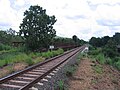
Railway bridges over Adelaide River: in front those of the Central Australian Railway , in the back those of the former North Australian Railway

Jumping crocodile
A video of the Adelaide River
.jpg)


See also
Web links
Individual evidence
- ^ A b c Map of Adelaide River, NT . Bonzle.com
- ^ Steve Parish: Australian Touring Atlas . Steve Parish Publishing, Archerfield QLD 2007. ISBN 978-1-74193-232-4 . P. 95
- ↑ Adelaide River on Encyclopædia Britannica Online ( English ) Retrieved on June 6 in 2009.