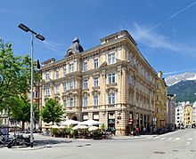
Adolf-Pichler-Platz
The Adolf-Pichler-Platz is a place in Innsbruck , the end of the 19th century was built on the site of the former town cemetery.
location
The square is located in Innsbruck city center at the rear of the town hall complex between Stainerstrasse and Fallmerayerstrasse. Today it connects the modern town hall complex that surrounds it in the east and south and the houses on the north and west side from the Wilhelminian era with Stainer and Fallmerayerstraße. The Bundesrealgymnasium Adolf-Pichler-Platz is on the east side . Colingasse branches off at the southwest corner.
history
The area was originally at the gates of the medieval city behind the hospital church and has been used as a hospital cemetery since the 14th century . In 1509/1510 the old city cemetery around St. Jacob's Church was abandoned and relocated to the hospital cemetery that was expanded for it. It was subsequently expanded and rebuilt several times. Due to its current location in the city, the cemetery was abandoned in 1856 and relocated to the Wilten fields, where today's Westfriedhof was built. By 1869 the site had been cleared and the cemetery chapel torn down, and individual graves were transferred to the new cemetery. The newly created square was initially used as a timber market. In 1869/70 the hospital building was expanded, and after the hospital was relocated, it served the secondary school (today's Adolf-Pichler-Platz high school) from 1890. In 1878 the buildings were erected on the north and west sides of the square, in 1896 Stainerstraße was created as a connection to the Marktgraben. In 1909 the monument to Adolf Pichler was erected in the middle of the square.
During the Second World War, vegetable beds were created on the square out of necessity. In the course of the air raids, an underground fire-fighting water tank was built under Adolf-Pichler-Platz, as in many other places in the city. Air bombs destroyed or damaged numerous buildings in the area on December 16, 1944, but the monument remained intact. After the war, the space with trees and bushes remained largely unused, and a children's playground was only created in 1994. In 2000/2001 it was redesigned as part of the new town hall building. Here found archaeological excavations take place. The bones found were buried in the Westfriedhof.
Surname
After the cemetery was closed, the square was initially referred to as the square of the old hospital garden or the square of the old cemetery , and later because of its use as a wood market as the new market . In 1896 the local council decided to name it Karl-Ludwig-Platz after the Austrian Archduke Karl Ludwig , who resided in Innsbruck as governor from 1855 to 1861. Applications to rename the square to Freiheitsplatz (1909) or Peter-Mayr- Platz (1926) were rejected. It got its present name after a unanimous council resolution on March 6, 1930. At the same time, the existing since 1899 Adolf-Pichler Street in Saggen renamed Conrad Street.
Adolf Pichler Monument
The monument to the geologist, mineralogist and writer Adolf Pichler was designed by Edmund Klotz in 1901 and unveiled on May 16, 1909. The larger than life bronze statue of the scholar stands on a curved marble plinth over two marble steps. He is shown in a slightly bent position and is wearing a mountain suit, he is holding a hat in his left hand and a geologist's hammer in his right .
literature
- Josefine Justic: Innsbruck street names. Where do they come from and what they mean . Tyrolia-Verlag, Innsbruck 2012, ISBN 978-3-7022-3213-9 , p. 9-11 .
- Alexander Zanesco: Cemeteries in old Innsbruck. The excavations at Adolf-Pichler-Platz. In: Zeit - Raum - Innsbruck, series of publications by the Innsbruck City Archives 1 (Innsbruck 2001), p. 12.
- Adolf-Pichler-Platz and its eventful history. In: Innsbruck informs, August 2000, special supplement Rathausprojekt Innsbruck, pp. 10–11. ( Digitized version )
- Karl Wiesauer: personality monument Adolf Pichler, Adolf Pichler monument. In: Tyrolean art register . Retrieved October 31, 2014 .
Web links
- Adolf-Pichler-Platz in the literary land map Tyrol / South Tyrol
Coordinates: 47 ° 15 ′ 57 " N , 11 ° 23 ′ 30.7" E

