Say
|
Say Statistical district |
|
|---|---|
| Basic data | |
| Pole. District , state | Innsbruck city (I), Tyrol |
| Pole. local community | Innsbruck ( KG Innsbruck ) |
| Locality | innsbruck |
| Coordinates | 47 ° 16 '34 " N , 11 ° 24' 16" E |
| height | 571 m above sea level A. |
| Residents of the stat. An H. | 5950 (2014) |
| Building status | 482 (2014) |
| surface | 95 ha |
| Post Code | 6020 Innsbruck |
| prefix | + 43/0512 (Innsbruck) |
| Statistical identification | |
| Statistical district | 4 sagas |
| Counting district / district | Saggen-West, Saggen-North (70101 X [06, 07]) |
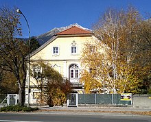
 The Saggen seen from the Hungerburg, left: block saw, right: villa sag |
|
| Source: STAT : index of places ; BEV : GEONAM ; TIRIS ; City of Innsbruck: Statistics - Numbers | |
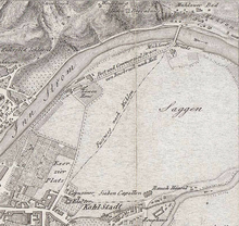
The Saggen is a district of the Tyrolean capital Innsbruck and part of the parliamentary group and cadastral municipality Innsbruck . Until the construction of the first Inn bridge to Mühlau, it formed a "sack" with no way out between Inn and Sill . With its villas, the Saggen represents an exemplary Wilhelminian-style ensemble , which reflects the wealth and social position of the builders and is now under ensemble protection.
Location and statistical data
The Saggen joins the city center to the northeast . The statistical district is bounded in the west and north by the Inn, in the east by the railway and in the south by the streets Kapuzinergasse - Kaiserjägerstraße - Karl-Kapferer-Straße. The district consists of the two statistical districts ( census districts ) Saggen-West (51.6 hectares, 1165 inhabitants, 203 buildings) and Saggen-North (43.4 hectares, 4785 inhabitants, 279 buildings; as of April 2014), which run through Falkstrasse , Conradstrasse and Claudiastrasse are to be separated. The district has 5950 inhabitants and a population density of 6263 inhabitants / km². 10.8% of the population are younger than 15 years, 23.2% older than 65. The proportion of foreigners is 15.8%.
history
Although consisting only of floodplains, the Saggen already appeared in the first document that mentions Innsbruck by name (allegedly from 1187, but it is a diplomatic forgery from the 2nd half of the 13th century) as a grazing area or cultural area of the Innsbruckers Citizens (" forenses de Insprucke ") on (" predium, quid dicitur Sacka "). Later on, the floodplains were part of the city's keep and still belonged de iure to the area of Wilten Abbey . From 1339 the eastern part of the area was transferred to the city as an interest loan, cleared and used as pasture area. With the establishment of the Curatie St. Jakob, the land power passed from the monastery to the church, and with that the area came to Innsbruck in 1453 as the property of the Wilten monastery.
Duke Friedrich IV. With the empty pocket acquired the area of today's Hofgarten as a pure hunting area as early as 1410 , which has been redesigned several times over the centuries. Under Archduke Ferdinand II , the court garden was also laid out, in which exotic animals were kept for exhibition fights. For this purpose the Bohemian House was built as a pheasantry and a lion house. The latter, however, burned down in 1636 and was later replaced by a brewery. In 1581 Archduke Ferdinand II had a bridge built over the Inn at the northern end of the Saggen , which was initially reserved for the court and served as a faster connection between Innsbruck and Hall and was opened to general traffic in 1643 in return for a bridge toll .
The Lower Inn Valley Railway, opened in 1858, crosses the district from the Inn Bridge in the east to the main train station entirely on a viaduct (viaduct arches).
Over the centuries, the Saggen was mainly used for agriculture, with the exception of a few buildings. In 1847 the Order of the Sister of Mercy acquired the chain bridge area and built a poor house. In 1862 the monastery was finally moved here and the mother house church was built in 1881/83. The sanatorium was added in 1910. Between 1868 and 1872 the monastery and church of Perpetual Adoration were built, but they were closed during the Nazi era .
A development plan drawn up in 1886 provided for today's Villensaggen (open development with gardens) with a road network in the form of a miter . A second wave of building began in 1898 with the block sawing (rows of houses on several floors with inner courtyards). Architecturally, the Saggen reflects the early days with their historicism .
During this time, one of Innsbruck's greatest benefactors, Johann von Sieberer , founded an orphanage (1886) and asylum for old people (1909).
The wooden summer theater on Rennweg , which has existed since 1892 , in which u. a. the Exl-stage appeared, burned down in 1958 and was replaced by the new building of the ORF -Landesstudios Tirol.
A hall made of glass and steel was built for the Tyrolean State Exhibition in 1893 and formed the basis for the Innsbruck trade fair area, which is still located on this site today . In the immediate vicinity, the wooden rotunda of the giant circular painting was created in 1897 , which in 1907 was moved to a brick building next to the valley station of the Hungerburgbahn , which opened in 1906 . Since December 1, 2007, the valley station of the Hungerburgbahn is no longer at the Chain Bridge to Mühlau, but at the Congress House (Dogana) , with a station on Rennweg (Löwenhaus).
The commercial academy building was built between 1904 and 1906 . In addition, the Protestant Christ Church was built in 1905/06. In 1912, the Innsbruck Jewish community acquired a plot of land in Gutenbergstrasse, which was sold again in 1936. The construction of a synagogue was planned on the property.
In 1930, a separate church was built for the residents of the district in the immediate vicinity of the elementary and secondary school of the Sisters of Mercy. After Saggen became a curate in 1940, the church finally became the parish church of the newly raised parish in 1949 . In 1965/66 the new parish church of Our Lady was built and the previous building was demolished in 1972.
In November 1974 the new Innsbruck gasworks was opened at the eastern end of the Saggen at the confluence of the Inn and Sill (the so-called "Sillzwickel"). The old gasworks in Pradl was then torn down; The Rapoldipark is located on this area today .
coat of arms
Since only municipalities are authorized to do so in Tyrol, the Saggen does not have an official coat of arms. As for the other Innsbruck districts, an unofficial district coat of arms was designed, which was adopted in 1993 by representatives of the Saggen associations. In the green and gold split shield, it shows an upright, right-facing, golden lion , whose chest is covered with the binding shield , and in the rear, golden field the green so-called "bishop's cap", divided once vertically and four times horizontally, the core of the first development plan drawn up in 1886.
The Habsburg lion is a reminder of the importance of sagging for court life at the Innsbruck Residence and the Löwenhaus am Inn, which was built together with the Bohemian Lusthaus under Archduke Ferdinand II.
Buildings and public facilities
- Federal Railway Directorate
- State Police Directorate Tyrol
- Gasworks
- Innsbruck exhibition center
- ORF regional studio
- Rotunda of the former giant circular painting
- Evangelical Christ Church , Evangelical Superintendenty AB Salzburg and Tyrol
- Canisianum
education
- Elementary school in Siebererstraße
- Special education center Daniel Sailer School
- Federal Commercial Academy and School Innsbruck
- Sisters of Charity Catholic Elementary School
- Catholic Secondary School of the Sisters of Mercy
- Catholic upper level secondary school Kettenbrücke
- Catholic educational institute for kindergarten pedagogy
Public transport
The district has multiple connections to the urban local transport network of the Innsbruck transport company . The tram line 1 runs from the Mühlauer Brücke (formerly the Chain Bridge) over the city center to Wilten , the bus line 504 connects the Saggen with Hall in Tirol , the line F with the airport , the line T with the industrial area Roßau and the west of the city ( Völs , via Südring), the lines A and 502 finally with the eastern outskirts ( MARTHA villages ).
Until 2005, the Hungerburgbahn connected the Saggen from the valley station at the Mühlauer Brücke with the Hungerburg district . Today there is a new HBB stop on Rennweg near the Löwenhaus .
Companies
- AlpenBank Aktiengesellschaft
- Publishing house of the Tiroler Tageszeitung
Web links
Individual evidence
- ↑ City of Innsbruck: Statistical classification of the districts of Innsbruck (PDF; 1.2 MB)
- ↑ City of Innsbruck: area, inhabitants and number of buildings of the individual census districts and statistical districts of the city of Innsbruck (as of April 2014) (PDF; 143 kB)
- ↑ City of Innsbruck: District mirror 2014 (PDF; 410 kB)
- ↑ Martin Bitschnau , Hannes Obermair : Tiroler Urkundenbuch , II. Department: The documents on the history of the Inn, Eisack and Pustertal valleys. Vol. 2: 1140-1200 . Universitätsverlag Wagner, Innsbruck 2012, ISBN 978-3-7030-0485-8 , p. 327–330 No. 817 (with detailed preliminary remarks).
- ^ Franz-Heinz Hye: Mühlau. A contribution to the history of the districts of Innsbruck. In: The window. Tyrolean culture magazine. Volume 17 (1975/76), pp. 1795–1803 ( PDF; 3.6 MB )
- ^ Franz-Heinz Hye : The district coat of arms of Saggen. In: Innsbrucker Stadtnachrichten, August 1993, p. 27 ( digitized version )


