Innsbruck (Innsbruck)
|
Innsbruck locality cadastral community Innsbruck
|
|
|---|---|
| Basic data | |
| Pole. District , state | Innsbruck city (I), Tyrol |
| Pole. local community | innsbruck |
| Coordinates | 47 ° 16 '1 " N , 11 ° 23' 41" E |
| height | 574 m above sea level A. |
| Residents of the village | 21,038 (January 1, 2020) |
| Area d. KG | 3.08 km² |
| Post Code | 6020 Innsbruck |
| prefix | + 43/0512 (Innsbruck) |
| Statistical identification | |
| Locality code | 16403 |
| Cadastral parish number | 81113 |
| Counting district / district | Old town, left bank of the Inn, Inner-City-North, Inner-City-West, Inner-City-East, Dreiheiligen, Saggen-West, Saggen-North, Saggen-East (70101 X [00,01,02,03,04, 05.06.07.08]) |
 View in south direction over the Saggen (front), Dreiheiligen (left) and the city center; in the background Wilten with the Bergisel |
|
| Source: STAT : index of places ; BEV : GEONAM ; TIRIS | |
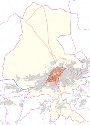
Innsbruck is a cadastral municipality and a fraction ( locality ) of the Tyrolean capital Innsbruck . Until the first incorporation in 1904, it was identical to the urban area of Innsbruck. It includes the historic old town , the former new town with Maria-Theresien-Straße , the Saggen, Dreiheiligen, as well as Mariahilf and St. Nikolaus on the left bank of the Inn.
location
The Innsbruck cadastral community is located in the center of the city and is surrounded on all sides by other Innsbruck cadastral communities. In the west it borders on Hötting , in the north, separated by the Inn , on Mühlau , in the east, mostly separated by the Sill , on Pradl and in the south on Wilten . The Innsbruck cadastral community has an area of 3.08 km². It is divided into the statistical districts of the city center , Mariahilf-St. Nikolaus , Dreiheiligen-Schlachthof and Saggen .
Districts
Downtown
The city center consists of the old town founded in 1180 and the later extensions to the south and east. The central axis is Maria-Theresien-Straße , which was previously called Neustadt . The Triumphal Gate at the southern end of the street forms the border with Wilten. Administrative institutions in town and country ( old and new country house , town hall ), retail and service companies (banks, insurance companies) and several higher schools make this area the actual center of the city.
Mariahilf-St. Nicholas
Mariahilf-St. Nikolaus is the oldest part of Innsbruck and was the only one on the left bank of the Inn until 1904. Around 1165 the Bavarian Counts von Andechs built a market settlement below Hötting, then called Anbruggen (from Latin Aenus , Rhaeto-Romanic En for Inn ). The dominant row of houses of Mariahilf and St. Nikolaus with their Gothic facades (partially redesigned) still characterizes the cityscape and is a popular photo motif. The area along the Inn in St. Nikolaus is also popularly called Koatlackn , as the sewage converged there when it was raining heavily. In the style of the historicism popular at the time , the church of St. Nikolaus was built in 1885, which is technically remarkable as it is the first church building with reinforced concrete vaults in Tyrol.
Dreiheiligen slaughterhouse
Dreiheiligen-Schlachthof extends northeast of the city center between the railway line and Sill . This area was originally called Kohlstatt . The name refers to a charcoal burner that was built to operate the princely silver smelter (around 1500). In its time, the area was, along with Mühlau, an important industrial area for Innsbruck. The quarter was expanded into a residential area in the early days . The current name Dreiheiligen comes from the parish church built in 1612 in honor of the plague saints Sebastian , Pirmin and Rochus . This is also where the city's largest inner-city trade center, the Sillpark Innsbruck, is located .
Say
The Saggen is the area north of the city center that the city acquired from Wilten Abbey in 1453 . With the exception of a few buildings, it was used primarily for agriculture in the past, until it was built on in the 19th century, first with Wilhelminian-style villas and then with apartment blocks.
Individual evidence
- ↑ City of Innsbruck: cadastral communities of Innsbruck (PDF; 1.3 MB)

