Wilten
|
Wilten ( district ) locality cadastral community Wilten |
|
|---|---|
| Basic data | |
| Pole. District , state | Innsbruck city (I), Tyrol |
| Pole. local community | innsbruck |
| Coordinates | 47 ° 15 '15 " N , 11 ° 23' 54" E |
| height | 585 m above sea level A. |
| Residents of the village | 17,754 (January 1, 2020) |
| Area d. KG | 6.75 km² |
| Post Code | 6020 Innsbruck |
| prefix | + 43/0512 (Innsbruck) |
| Statistical identification | |
| Locality code | 16407 |
| Cadastral parish number | 81136 |
| Counting district / district | Wilten-Ost, Wilten-Mitte, Wilten-Süd, Wilten-West, Sieglanger, Mentlberg (70101 X [10,11,12,13,14,15]) |
 Wiltener Platzl |
|
| Source: STAT : index of places ; BEV : GEONAM ; TIRIS | |
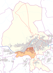
Wilten is a cadastral community , a fraction ( locality ) and a statistical district in the south of Innsbruck , at the foot of the Bergisel . In 1904 Wilten was incorporated. The Triumphal Gate forms the border to the city center .
Location and structure
The cadastral community Wilten covers an area of 6.75 km². It corresponds to the municipality of Wilten, which was independent until 1904. In the north it borders on the cadastral communities Hötting and Innsbruck , in the east on the cadastral community Pradl , in the south on the cadastral community Vill and the community Natters , in the west on Völs . The Inn forms the border with Hötting and the Maximilian and Salurner Strasse to Innsbruck. The cadastral community and parliamentary group are divided into the statistical districts of Wilten and Sieglanger-Mentlberg .
The statistical district Wilten comprises the statistical districts ( counting districts ) Wilten-Ost (40.5 ha, 4543 inhabitants, 391 buildings), Wilten-Mitte (73.9 ha, 5518 inhabitants, 551 buildings), Wilten-Süd (361.4 ha, 641 inhabitants, 183 buildings) and Wilten-West (45.0 ha, 3405 inhabitants, 234 buildings; as of April 2014). The district has 14,107 inhabitants and a population density of 2709 inhabitants / km². 8.9% of the population are younger than 15 years, 15.6% older than 65. The proportion of foreigners is 25.9% (as of 2013).
history
|
Wilten Statistical district |
|
|---|---|
| Basic data | |
| Pole. District , state | Innsbruck city (I), Tyrol |
| Pole. local community | Innsbruck ( KG Wilten) |
| Locality | Wilten |
| Coordinates | 47 ° 15 '15 " N , 11 ° 23' 54" E |
| Residents of the stat. An H. | 14,107 (2014) |
| Building status | 1359 (2014) |
| surface | 5.21 km² |
| Statistical identification | |
| Statistical district | 5 Wilten |
| Counting district / district | Wilten-Ost, Wilten-Mitte, Wilten-Süd, Wilten-West (70101 X [10,11,12,13]) |
| Wilten's plan | |

|
|
| Source: STAT : index of places ; BEV : GEONAM ; TIRIS ; City of Innsbruck: Statistics - Numbers | |
The first settlements in the Bergisel area can already be seen at the time of the Urnfield Culture around 1000 BC. Under the Romans , warehouses ( horrea ), a fort and the settlement ( vicus ) Veldidena , which was first mentioned in the 3rd century, were built. At that time, Veldidena was an important route and supply station on the Roman Brenner route Via Raetia , which connected Bozen (Pons Drusi) with Augsburg (Augusta Vindelicorum).
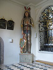
According to legend, Wilten Abbey was founded in the 9th century by the giant Haymon before it was handed over to the Premonstratensian order in 1138 . Until 1180, the entire area between today's Wilten and the Inn belonged to the Wilten Canons. Through an exchange deal with the Andechs counts , who had already built a small market settlement on a bridge on the left bank (then called Inspruk ), Innsbruck was re-established in 1180, where today's old town is located.
In older times Wilten was also called Wil (en) t (h); Even in the 14th century (1370) the form "Willentein de Inspruka" is attested.
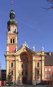
The collegiate church was built in 1665. In Wilten is still another important religious building, in 1756 by the Franz de Paula Penz in late Baroque style built Wiltener Basilica .
Wilten was part of the monastery’s territory and jurisdiction until the 19th century. In the course of the temporary cession of Tyrol during the Napoleonic wars to Bavaria in 1805 and the subsequent secularization of monasteries, the monastic court was dissolved and Wilten was considered a separate community.
Originally still a rural village, Wilten changed its appearance with the construction of the Arlbergbahn and the Wilten state train station (now Innsbruck Westbahnhof ) in 1883. New districts with an urban character emerged. In order to be able to solve infrastructural decisions together with the city of Innsbruck, after negotiations it was decided in 1904 to unite Wilten with Innsbruck.
Since 1891 the local railway Innsbruck – Hall in Tirol has been running from the Bergisel train station at Wilten Abbey via Innsbruck to Hall in Tirol . From 1905 inner-city lines of the Innsbruck tram followed .
coat of arms
Until the incorporation, Wilten had a coat of arms that is used again today as a district coat of arms. In a blue field it shows a round chapel standing on a green shield base, which is flanked on both sides by a red tent. The chapel represents the little St. Bartlmä church that can be traced back to 1275, the significance of the tents is not known. The use of the coat of arms can be proven since 1867. Nothing is known of an official award, presumably the coat of arms was introduced by the municipality of Wilten itself, without imperial confirmation, but with tacit approval by the state authorities.
Culture and sights
- Bartlmäkirchlein : reconstructed, originally around 800, completely destroyed in 1944 after a direct bombing hit
Districts
Wiltenberg describes the slope in the south and the area near the Westbahnhof with a commercial zone.
Mentlberg is a residential area on the hillside, south of the road to Fiè , consisting mainly of single-family houses and villas. The traditional Peterbrünnl inn and the Mentlberg animal shelter are also well known. Noteworthy is the 1905 in the style of historicism modeled after French Loire castles converted castle Mentlberg .
Sieglanger is northwest of it on the Inn, with the Maria am Gestade church with glass mosaics by Max Weiler . This Roman Catholic Church, as well as the neighboring kindergarten and elementary school, is responsible for Sieglanger, Mentlberg and Klosteranger. Sieglanger is also a housing estate consisting of residential houses, single-family houses, many similarly built row houses with steep pitched roofs, which strongly characterize the appearance of the Sieglanger, and some villas.
Klosteranger , also a residential area, lies to the south, running parallel to the Sieglanger district.
Infrastructure and traffic
In addition to the local infrastructure, Wilten also has facilities that are important for the city as a whole or supraregional, such as parts of the university and the university clinic , the Westfriedhof or the Tyrolean University of Education .
Wilten is the starting point for several traffic routes: the Brenner federal road (with the connection Innsbruck-Süd to the Brenner motorway ), the Stubaitalbahn and line 1 and line 6 of the Innsbruck tram . In the west there is a connection (Innsbruck West) to the A 12 Inntal motorway .
Personalities
- Ferdinand von Bissingen-Nippenburg (1749–1831), civil servant and politician
- Heinrich Hueter (1844–1925), politician and alpinist
- Hans Bernard (1861–1945), sculptor
- Martin Spörr (1866–1937), musician, conductor and composer
- Karl Radinger von Radinghofen (1869–1921), classical philologist, art and cultural historian
- Fanny Inama von Sternegg (1870–1928), painter
- Karl Inama von Sternegg (1871–1931), genealogist and heraldist
- Simon Abram (1871-1940), politician
- Otto Nussbaumer (1876–1930), physicist and radio pioneer
- Franz Fischer (1887–1943), politician, mayor of Innsbruck
Web links
- Entry on Wilten in the Austria Forum (in the AEIOU Austria Lexicon )
- Wilten , in the history database ofthe association "fontes historiae - sources of history"
Individual evidence
- ↑ City of Innsbruck: cadastral communities of Innsbruck (PDF; 1.3 MB)
- ↑ City of Innsbruck: area, inhabitants and number of buildings of the individual census districts and statistical districts of the city of Innsbruck (as of April 2014) (PDF; 143 kB)
- ↑ City of Innsbruck: District Mirror 2014 ( Memento from October 21, 2018 in the Internet Archive ) (PDF; 410 kB)
- ^ Hannes Obermair : Bozen Süd - Bolzano Nord. Written form and documentary tradition of the city of Bozen up to 1500 . tape 1 . City of Bozen, Bozen 2005, ISBN 88-901870-0-X , p. 372, no.768 .
- ^ Wilten rifle company: On the history of the Wilten coat of arms ( Memento from October 15, 2014 in the Internet Archive )
- ↑ St. Bartlmä ( memento from September 6, 2013 in the Internet Archive ) , stift-wilten.at; therefore not under monument protection


