Sieglanger-Mentlberg
|
Sieglanger-Mentlberg Statistical district |
|
|---|---|
| Basic data | |
| Pole. District , state | Innsbruck city (I), Tyrol |
| Pole. local community | Innsbruck ( KG Wilten ) |
| Locality | Wilten |
| Coordinates (K) | 47 ° 15 '8 " N , 11 ° 21' 51" E |
| height | 577 m above sea level A. |
| Residents of the stat. An H. | 2731 (2014) |
| Building status | 497 (2014) |
| surface | 1.56 km² |
| Post Code | 6020 Innsbruck |
| prefix | + 43/0512 (Innsbruck) |
| Statistical identification | |
| Statistical district | 6 Sieglanger-Mentlberg |
| Counting district / district | Sieglanger, Mentlberg (70101 X [14,15]) |
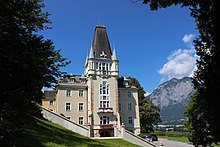
 View of Mentlberg from the Inn |
|
| Source: STAT : index of places ; BEV : GEONAM ; TIRIS ; City of Innsbruck: Statistics - Numbers ;
(K) Coordinate not official
|
|
Sieglanger-Mentlberg (also Sieglanger / Mentlberg ) is a district in the south-west of Innsbruck .
Location and statistical data
Sieglanger-Mentlberg is one of the 20 statistical districts of Innsbruck, it belongs to the cadastral municipality and fraction Wilten . Mentlberg is located on the steep slope of the Wiltenberg, which extends to the Inn , to the west of it the Sieglanger lies on a narrow, elongated flat area between the Inn and the Inntal Autobahn in the north and the Arlbergbahn in the south.
The district borders in the east on the statistical district Wilten, in the north, separated by the Inn, on the Höttinger Au , in the west on Völs and in the south on Natters .
The district consists of the two statistical districts ( counting districts ) Sieglanger (29.1 ha, 1103 inhabitants, 200 buildings) and Mentlberg (127.2 ha, 1628 inhabitants, 297 buildings; as of April 2014), which are separated by the railway line. The district has 2731 inhabitants and a population density of 1747 inhabitants / km². 13.2% of the population are younger than 15 years, 14.7% older than 65. The proportion of foreigners is 21.6% (as of 2013).
history
Around 1490 Heinrich Mentlberger expanded the Meierhof on the Gallwiese into a noble residence, today's Castle Mentlberg , which was rebuilt several times . The Mentlberg pilgrimage church was consecrated in 1770 . The Peterbrünnl Inn was built in 1874 and the brickworks in 1875 in the area of today's prison ("Ziegelstadl"). The Felseck residence on Wiltenberg followed in 1880. The area belonging to Wilten became part of Innsbruck in 1904.
In 1934, two settlements for the unemployed were built in the plain on the Inn called Sieglanger . The city built 20 settlement houses, which were named after the then mayor Franz Fischer Fischersiedlung . To the west of it, the “Heim” building cooperative built the Dollfußsiedlung (named after Chancellor Engelbert Dollfuß, who was murdered in 1934 ) with 33 houses. The houses were built with the strong participation of the residents and each had a 900 m² garden for self-sufficiency. In the post-war period, further residential buildings were built, and later multi-storey apartment buildings. In 1962 the parish church Maria am Gestade was consecrated in the center of Sieglanger .
After the Second World War, the Mentlbergsiedlung was built on the slope of Wiltenberg according to a development plan from 1929. Most of the single-family houses were built between 1945 and 1960. The settlement on the Klosteranger between the railway line and Völser Straße also developed in the post-war period.
Between Sieglangeriedlung and Inn, the first lane of the Inntal Autobahn was laid in 1964 and the second in 1975 . To protect the population, Austria's first noise protection wall was erected on a motorway here in 1978 .
traffic
The district is located at the Innsbruck-West junction of the Inntal Autobahn and on Völser Straße (L11). Mentlberg which Sieglanger and the monastery Anger over each branch roads opened up by the Völser road. As a cable-stayed bridge, the Sieglangersteg spans the Autobahn and the Inn and creates a connection for pedestrians and cyclists to the Höttinger Au . The Sieglanger is connected to the city center by bus line C, Mentlberg by bus line M of the Innsbrucker Verkehrsbetriebe . The Arlbergbahn runs through the district without stopping, but there are considerations to establish a stop for the S-Bahn Tirol .
Web links
Individual evidence
- ↑ City of Innsbruck: area, inhabitants and number of buildings of the individual census districts and statistical districts of the city of Innsbruck (as of April 2014) (PDF; 143 kB)
- ↑ City of Innsbruck: District mirror 2014 (PDF; 410 kB)
- ↑ a b c On the development of Sieglanger / Mentlberg. In: Innsbrucker Stadtnachrichten, No. 11, 1985, pp. 11–14 ( digitized version )
- ^ "Sieglanger" suburban housing estate in Innsbruck. In: Official Journal of the State Capital Innsbruck, No. 3, 1935, pp. 1–4 ( digitized version )
- ↑ Axel Borsdorf: Innsbruck: From City to Cyta? Outskirt development as an indicator of spatial, economic and social development. In: G. Dubois-Taine (ed.): From Helsinki to Nicosia. Eleven case studies and synthesis. European Cities. Insights on Outskirts. Paris 2004, pp. 75-96. ( Digitized version )
- ^ Parish Maria am Gestade: History of the parish Maria am Gestade
- ↑ Bernd Kreuzer: The construction of the motorways and expressways in Austria. In: The motorway network in Austria. 30 years of ASFINAG. Vienna 2012, pp. 11–120. ( PDF; 7.6 MB ( memento from January 1, 2015 in the Internet Archive ))
- ↑ Less motorway noise for Mentlberg. In: Innsbruck informs, June 2002, p. 11 ( digitized version )
- ↑ S-Bahn: direct connection between Telfs and Hall every half hour from autumn! ( Memento from March 4, 2016 in the Internet Archive ), Verkehrsverbund Tirol, April 26, 2007


