
Vill (Innsbruck)
|
Vill ( village ) locality cadastral community Vill District Innsbruck |
|
|---|---|
 |
|
| Basic data | |
| Pole. District , state | Innsbruck city (I), Tyrol |
| Judicial district | Innsbruck (city) |
| Pole. local community | innsbruck |
| Coordinates | 47 ° 14 '9 " N , 11 ° 24' 8" E |
| height | 817 m above sea level A. |
| Residents of the village | 531 (January 1, 2020) |
| Building status | 215 (2014) |
| Area d. KG | 3.67 km² |
| Post Code | 6080 Innsbruck |
| Primaries | + 43 / (0) 512 (Innsbruck) |
| Statistical identification | |
| Locality code | 16406 |
| Cadastral parish number | 81103 |
| District of Innsbruck | 7 Vill |
| Counting district / district | Vill (70101 70 [0]) |
 Vill |
|
| Former municipality (until 1942) Source: STAT : Place directory ; BEV : GEONAM ; TIRIS ; City of Innsbruck |
|
Vill is a village as well as a district , cadastral community and locality of the city of Innsbruck . In 1942 it was incorporated into Innsbruck.
geography

The place is located south of the center of Innsbruck , on the slope of a low mountain range at the foot of the Patscherkofel , at an altitude of around 820 m . In Vill the Viller Bach flows together with the five kilometer long Ramsbach coming from Igls , and then down to the Sill in the Sillschlucht . Igls, the well-known winter sports resort, which is also a district of Innsbruck, is 1.5 km south of Vill.
Vill still has a village appearance today with a number of farms. The district and local area also include Grillhof and Poltenhütte northeast of the village on Lanser Kopf ( 930 m above sea level ), and Handlhof and Zenzenhof south on the Sill below Igls, as well as the municipal areas around the Ahrnwald up to the southern border of Innsbruck at the bus stop Unterberg-Stefansbrücke of the Brennerbahn .
Neighborhoods / cadastral communities:
| Wilten | Pradl | |
| Natters (gem.) |
.svg)
|
Lans (gem.) |
| Mother (gem.) | Patsch (gem.) | Igls |
Statistical data
The statistical district Vill is congruent with the cadastral municipality and the statistical district ( census district ) Vill and has an area of 366.8 ha, 541 residents with main residence in Vill and 58 people with secondary residence (as of end of 2014) and 215 buildings (as of April 2014 ). 16.5% of the population are younger than 15 years, 24.5% older than 65. The proportion of foreigners is 8.7% (as of 2013).
politics
Until 1942 Vill was an independent municipality, the last mayor of Vill was Karl Schlögl. In 1942 the place was incorporated into Innsbruck by ordinance of the National Socialist administration. After 1945 some Viller farmers tried unsuccessfully to reverse this incorporation. The political integration into the city of Innsbruck is now generally accepted.
In order to make the concerns of the Viller population better heard in the Innsbruck municipal council, the establishment of a Vill district committee was initiated in 2012. In the election to the district committee held on April 28, 2013 parallel to the state elections, 249 villagers voted, which corresponded to a participation of 57.24% of the eligible voters. The constituent meeting of the Vill district committee took place on July 12, 2013 in the Grillhof. Max Profanter was appointed as chairman of the subcommittee, and Klaus Jennewein as its deputy.
History, culture and sights
Finds from the La Tène period were made in Vill . Stone remains of a former dwelling on a hill were found on the Goarmbichl .
The name has a Romance language root. The "Villertal" (as the valley of the Viller Baches) is mentioned for the first time in 1141 in the (forged) documents of Wilten Abbey . 1251 the "villa Ville" is mentioned in a document. The present name of the village was derived from this. The same document also mentions Viller Straße ( “via tendens ad villam Ville” ), at that time a cart path from the Wiltener Sillbrücke to Vill with a different course than today. In 1313 Vill was mentioned as a corridor and tax municipality of the Sonnenburg court .
In the 13th century, the Counts of Tyrol had Strasbourg Castle built to guard the road from Innsbruck via Vill and Igls to Patsch. After the local family died out, the castle began to deteriorate in the 16th century.
The parish church of St. Martin has been proven by a deed of foundation since 1397. It still shows the Gothic style of its construction, but was redesigned in 1790 in the Rococo style. Like Igls, Vill was part of the original Patsch parish , but has been looked after by Wilten Abbey since 1259 . In 1808 Igls and Vill became a curate , and in 1891 a parish, which however remained incorporated into Wilten Abbey .
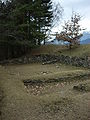
Goarmbichl , finds from the La Tène period


coat of arms
Unlike Wilten , Hötting or Mühlau , Vill did not have a coat of arms when it was incorporated. Therefore, in 1992 it received a newly created district coat of arms, which was unanimously accepted by the representatives of the Viller associations. In a shield divided diagonally from red to white, the upper red field shows a representation of the upright bishop Martin of Tours with miter and the shepherd's crook in his left hand and the white goose at his feet, while the lower field shows a representation of the prehistoric Viller bronze wheel. The coat of arms commemorates the church patron and the excavations at Goarmbichl, Innsbruck's only open-air museum.
Web links
- Vill , in the history database ofthe association "fontes historiae - sources of history"
- Official website of the Vill district council
Individual evidence
- ↑ See spatial reference system , Statistics and Reporting Unit, innsbruck.gv.at → Office | Administration → Statistics | Figures ; in particular the documents given there: spatial reference system and plan presentation of the cadastral communities , the statistical city districts and the statistical districts
- ↑ 4. Communication from the Vill district council, p. 4 (February 2015)
- ↑ City of Innsbruck: area, inhabitants and number of buildings of the individual census districts and statistical districts of the city of Innsbruck (as of April 2014) (PDF; 143 kB)
- ↑ City of Innsbruck: District mirror 2014 (PDF; 410 kB)
- ^ 1. Communication from the Viller District Committee, p. 6 (March 2014)
- ^ Minutes of the constituent meeting of the Vill district committee
- ↑ Martin Bitschnau , Hannes Obermair : Tiroler Urkundenbuch , II. Abt .: The documents on the history of the Inn, Eisack and Pustertal valleys . Volume 2: 1140-1200 . Innsbruck: Wagner 2012. ISBN 978-3-7030-0485-8 , pp. 144ff. No. 392 (with a detailed discussion of the tradition forged in the 13th century).
- ^ A b Franz-Heinz Hye : Now Vill also has a district coat of arms. In: Stadtnachrichten, April 1992, p. 19 ( digitized version )

Cadastral communities, localities and districts: Amras | Arzl | Hötting | Igls | Innsbruck | Mühlau | Pradl | Vill | Wilten
Statistical districts: city center | Mariahilf-St. Nicholas | Dreiheiligen slaughterhouse | Saggen | Wilten | Sieglanger-Mentlberg | Pradl | Reichenau | Hötting | Höttinger Au | Hötting West | Hungerburg | Mühlau | Industrial area Mühlau / Arzl | Arzl | Olympic Village | Amras | Commercial area Roßau | Vill | Igls
City districts (settlement identification) :
Amras •
Arzl •
Hötting •
Innsbruck •
Mühlau •
Olympic village •
Pradl •
Wilten
villages:
Igls •
Vill |
Rotten:
Finkenberg •
Untere Figge |
Settlements:
Allerheiligenhöfe •
Egerdach •
Hungerburg-Hötting •
Hungerburg-Mühlau •
Kranebitten •
Mentlbergsiedlung •
Sieglanger •
Sadrach |
Groups of houses:
Alpenzoo •
Mount of Olives |
Other locations:
Ambras Castle •
Arzler Alm •
Innsbruck Airport •
Gluirschhöfe •
Grillhof •
Gramartboden •
Hafelekar mountain station •
Handlhof •
Harterhof •
Holy Year settlement •
Heiligwasser •
Hohenburg Castle •
Hörtnagl settlement •
Höttinger Alm •
Höttinger Bild •
Lohbach settlement •
Mariahilf •
Mentlberg Castle •
Mentlbergsiedlung •
Möslalm •
Neuarzl •
Peerhofsiedlung •
Pfeishütte •
Planötzenhof •
Roßau •
St. Nikolaus •
Seegrube station •
Taxburg Castle •
Tivoli •
Zenzenhof
Counting districts: Old Town | Left bank of the Inn | Inner City North | Inner City-West | Inner City East | Holy Trinity | Saggen-West | Saggen-North | Saggen-East | Wilten-Ost | Wilten-Mitte | Wilten-South | Wilten-West | Sieglanger | Mentlberg | Pradl-North | Pradl-Mitte-West | Pradl-Middle-East | Pradl-South | Pradl-East | Reichenau-West | Reichenau-East | Hötting center | Hungerburg-Hötting | Höttinger Au-Ost | Höttinger Au-West | Lohbach settlement | Hörtnaglsiedlung | Hötting-West | Mühlau village | Hungerburg-Mühlau | Mühlau-Ost | Mühlau shooting range | Amras-South | Amras-West | Amras North | Arzl-Dorf | Arzl-West | Arzl-South | Arzl Olympic Village | Vill | Igls