Aegidienstraße (Lübeck)


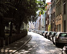
The Aegidienstraße is a street in Lübeck .
location
Aegidienstraße is located in the south-eastern part of the old town island of the Hanseatic city of Lübeck ( Johannis Quartier ) and runs in a west-east direction. It begins on Klingenberg and ends on the north side of St. Aegidien Church when it meets Balauerfohr , Stavenstraße and St.-Annen-Straße . It borders the Aegidienkirchhof .
history
Aegidienstraße was first documented in 1286 as “Platea Sancti Egidii”. In the following centuries, the spelling of the street name in the documents that have survived shows considerable variations:
- 1438: “St. Illienstrate "
- 1460: "St. Illigenstrate "and" St. Ilgenstrate "
- 1666: "Eydienstrate" and "Ottilienstraße"
“Aegidienstraße” has been the officially established spelling since 1852. However, in 1909 "Tilgenstrate" was still a widely used alternative name.
All variants are derived from the St. Aegidien Church, which is named after St. Aegidius and, like the road leading to it, has been given very different and sometimes barely recognizable variations of its name over the centuries.
Today's Schildstraße branching off to the south was considered part of Aegidienstraße until the late 19th century and was designated with the addition “up dem Ruggen”, while the northern arm was given the additional name “tegen den Scheren”. It was not until 1884 that the southern branch became "Schildstraße".
Buildings
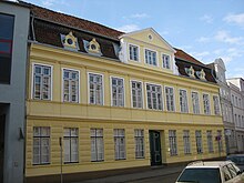
- Aegidienstraße 18 , a classicist house dating back to the 14th century from 1875
- Aegidienstraße 20 , a classicist house from 1803 dating back to the 14th century
- Aegidienstraße 22 , the Geverdeshof , baroque city palace from 1779, today the seat of the Hahn company
- Aegidienstraße 24 , a baroque house dating back to the 14th century, at the fork to Schildstraße
- Aegidienstraße 35 , an early classicist house from the late 18th century dating back to the 13th century
- Aegidienstraße 55–57 , Renaissance house probably from the 17th century
- Aegidienstraße 59 , baroque house from 1754
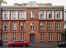
- Aegidienstraße 65 , returning to the early 17th century former poorhouse donated by the mayor Heinrich Köhler and after him Kölerstift named street side in the style of 1872 eclecticism rebuilt
- Aegidienstraße 67 , a classicist house dating back to the 14th century from the early 19th century
- Aegidienstraße 75 , a classicist house dating back to the 14th century from 1831
- Aegidienstraße 77 , classicist brick pastor's house from St. Aegidien, built 1826–1828
- See also list of abandoned buildings in Lübeck # Aegidienstraße for buildings that no longer exist.
Corridors and courtyards
The following Lübeck corridors and courtyards walk from Aegidienstraße (according to house numbers):
- 25: Carsten's poor walk
- 47: Passage (to Wahmstraße )
- 65: Köhler's poor house
- 69/71: Rosenberg's walk
- 75: Henks Gang (removed in 1875 when the front building was converted)
literature
- W. Brehmer : The street names in the city of Lübeck and its suburbs. HG Rathgens, Lübeck 1889.
- Klaus J. Groth : World Heritage Lübeck - Listed Houses. Over 1000 portraits of the listed buildings in the old town. Listed alphabetically by streets. Verlag Schmidt-Römhild, Lübeck 1999, ISBN 3-7950-1231-7 .
- Max Hoffmann: The streets of the city of Lübeck. In: Journal of the Association for Lübeck History and Archeology. Jg. 11, 1909, ISSN 0083-5609 , pp. 215-292 (also special print: 1909).
Web links
Coordinates: 53 ° 51 '51.5 " N , 10 ° 41' 17.2" E


