Aghitu
Aghitu ( Armenian Աղիտու ), until April 1991 Aghudi , is a village and a rural community ( hamaynkner ) in the southern Armenian province of Sjunik near Sissian . The place is known for an unusual early Christian tomb.
location
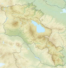
Coordinates: 39 ° 30 ′ 55 ″ N , 46 ° 4 ′ 51 ″ E
Aghitu is located at an altitude of 1700 meters on the slope of a chain of hills above a deep gorge running from northwest to southeast, through which the Vorotan flows. The high altitudes are treeless and rocky, in some cases the basalt rock protrudes massively and forms jagged edges. The grassy slopes are used as pastureland, apple trees only thrive in isolated spots in the area.
A road from Sissian leads on the left bank above the Vorotan after five kilometers through Aghitu and after another five kilometers past the ruins of the Vorotnavank monastery . Long-distance traffic on this old trade route along the river valley has now been shifted to the M2 expressway , which runs further north over the plateau. Between Aghitu and Vorotnavank, a side road branches off north to the village of Noravan, which can also be reached from the M2 between Sissian and Goris . The next village from Aghitu, one kilometer after Vorotnavank down on the river bank, is Vorotan , which is dominated by the Vorotnaberd castle hill .
History and appearance
Artifacts from the Upper Paleolithic have been found in caves at the foot of a nearby hill . There were late Bronze Age and Iron Age settlements and tombs on the plateau of the hill, as in Zorakarer (beginning of the 2nd to the 1st millennium BC). The ancient Greek inhabitants experienced in the 1st century BC The invasion of Roman soldiers. Medieval chronicles mention an important monastery with a fortress in Aghitu, but there are no remains of it.
The word Aghudi is said to be derived from agh , “landed property”, so the name of the place belonged to the lands of local princes in later times. Turkmen ranchers had settled in Aghudi and built a mosque until they fled Armenian immigrants in the 19th century . The mosque disappeared today. A cemetery with mostly broken tombstones on the hillside above the road on the western edge of the village (at the place name sign) tells of the Muslim residents.
In the 2001 census, the official population was 209, which is a third lower than in 2009. In January 2009, according to official statistics, there were 304 inhabitants in Aghitu. Another estimate gives 500 inhabitants for this year.
Grave construction
The most important monument in the village is an unusual grave building, which is dated to the 6th or 7th century, i.e. it was built before the development of the Khachkare , which is important for the Armenian-Christian culture of remembrance . Coming from Sissian it is located at the beginning of the village on the right of the street. The lower part is a rectangular building made of basalt blocks with two arched portals on the western side, which was probably planned as a mausoleum . An equally smaller room was built in the north of the barrel-vaulted main room, which only receives light through the open portal. A steep eight-step staircase leads to the platform from the rear in the middle. On top of this stands an octagonal column with a volute capital , from which round arches lead to lateral semicircular wall templates on flanking rectangular pylons as an outer boundary. Above it finally follows a structure with two vase-like columns and three round arches, this time resting on the side of rectangular pilasters on the outer pillars. The upper part, which was destroyed in an earthquake in 1931, has been restored. Pomegranates, grapes, serpentine lines and other vegetable patterns are used as ornaments. The entire three-tier composition with its stylistically diverse architectural elements and ornamental details appears to be put together. Who was the client and who was buried here is unknown. The only comparable tomb in Armenia is next to Odsun Cathedral .
Some Arabic and Armenian inscriptions on the grave are ascribed to the 9th to 13th centuries. To the north of the grave are remains of the wall, which may have become a single-nave chapel from the 10th / 11th. Century, and in the area there are medieval tombstones from the once larger complex. It is possible that there was a previous Roman building from the 1st century BC at this point. The tomb of Aghitu is depicted on the 1000 Dram banknote issued in 1994 , which was valid until 2004.
Web links
- Rick Ney: Siunik . (PDF; 1.6 MB) TourArmenia, 2009, p. 16
Individual evidence
- ↑ Genocide and Deportation of Azerbaijanis . (PDF; 3.2 MB) Administrative Department of the President of the Republic of Azerbaijan, p. 102
- ↑ Boris Gasparyan, Andrew Kandel, Cyril Montoya: Living the High Life: The Upper Paleolithic Settlement of the Armenian Highlands. In: Boris Gasparyan, Makoto Arimura (ed.): Stone Age of Armenia. A Guide-book to the Stone Age Archeology in the Republic of Armenia. Monograph of the JSPS-Bilateral Joint Research Project Center for Cultural Resource Studies, Kanazawa University 2014, pp. 107-131, ISBN 9784990807009
- ↑ Rick Ney, p. 16
- ^ RA Syunik Marz. Marzes of the Republic of Armenia in Figures 2009. (PDF; 284 kB) armstat.am, p. 260
- ^ RA 2001 Population and Housing Census Results. (PDF; 927 kB) armstat.am; Rick Ney, p. 16
- ↑ Aghudi Memorial . ( Memento of November 5, 2013 in the Internet Archive ) Armenia Information
- ↑ Aghudi . ( Memento of November 5, 2013 in the Internet Archive ) Gateway to Armenian Cultural Heritage
- ↑ Aghudi Memorial. Armeniapedia; Rick Ney, p. 16


