
Alcazar de San Juan
| Alcázar de San Juan parish | |||
|---|---|---|---|
 Windmills on the Campo de Criptana
|
|||
| coat of arms | Map of Spain | ||

|
|
||
| Basic data | |||
| Autonomous Community : | Castile-La Mancha | ||
| Province : | Ciudad Real | ||
| Coordinates | 39 ° 24 ′ N , 3 ° 12 ′ W | ||
| Height : | 644 msnm | ||
| Area : | 666.78 km² | ||
| Residents : | 30,576 (Jan 1, 2019) | ||
| Population density : | 45.86 inhabitants / km² | ||
| Postal code : | 13600 | ||
| Municipality number ( INE ): | 13005 | ||
| administration | |||
| Mayor : | José Fernando Sánchez Bódalo ( PSOE ) | ||
| Website : | www.alcazardesanjuan.es | ||

Alcázar de San Juan , often just called Alcázar for short , is a city with 30,576 inhabitants located south of Madrid . It belongs to the Spanish province of Ciudad Real in the autonomous community of Castile-La Mancha .
To the east there are three lakes: "La Veguilla", "Laguna del Camino de Villafranca" and "Laguna de Las Yeguas".
Alcázar de San Juan has long been known as a central railway junction between Madrid, Albacete (further towards Murcia ) and Valdepenas and to the southwest. The station is worth seeing and is a stop on a rapid transit line.
Attractions
- Windmills in the region
- Torreón del Gran Prior (14th century)
- Parish Church of Santa Maria (13th to 15th centuries)
- San Francisco Church (14th to 15th centuries)
- Santa Clara Monastery (16th century)
Literary meaning
The book Don Quixote by Miguel de Cervantes is mainly set in the Alcázar de San Juan.
photos
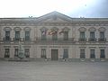
town hall

Statue of Cervantes

Church of St. Francis (San Francisco)

Church of Santa Quiteria

Santa María Church
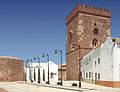
Grand Prior's Tower


Web links
swell
- ↑ Cifras oficiales de población resultantes de la revisión del Padrón municipal a 1 de enero . Population statistics from the Instituto Nacional de Estadística (population update).
Abenójar | Agudo | Alamillo | Albaladejo | Alcázar de San Juan | Alcoba | Alcolea de Calatrava | Alcubillas | Aldea del Rey | Alhambra | Almadén | Almadenejos | Almagro | Almedina | Almodóvar del Campo | Almuradiel | Anchuras | Arenales de San Gregorio | Arenas de San Juan | Argamasilla de Alba | Argamasilla de Calatrava | Arroba de los Montes | Ballesteros de Calatrava | Bolaños de Calatrava | Brazatortas | Cabezarados | Cabezarrubias del Puerto | Calzada de Calatrava | Campo de Criptana | Cañada de Calatrava | Caracuel de Calatrava | Carrión de Calatrava | Carrizosa | Castellar de Santiago | Chillón | Ciudad Real | Corral de Calatrava | Los Cortijos | Cózar | Daimiel | Fernán Caballero | Fontanarejo | Fuencaliente | Fuenllana | Fuente el Fresno | Granátula de Calatrava | Guadalmez | Herencia | Hinojosas de Calatrava | Horcajo de los Montes | Las Labores | Llanos del Caudillo | Luciana | Malagón | Manzanares | Membrilla | Mestanza | Miguelturra | Montiel | Morale de Calatrava | Navalpino | Navas de Estena | Pedro Muñoz | Picón | Piedrabuena | Poblete | Porzuna | Pozuelo de Calatrava | Los Pozuelos de Calatrava | Puebla de Don Rodrigo | Puebla del Príncipe | Puerto Lápice | Puertollano | Retuerta del Bullaque | El Robledo | Ruidera | Saceruela | San Carlos del Valle | San Lorenzo de Calatrava | Santa Cruz de los Cáñamos | Santa Cruz de Mudela | Socuéllamos | La Solana | Solana del Pino | Terrinches | Tomelloso | Torralba de Calatrava | Torre de Juan Abad | Torrenueva | Valdemanco del Esteras | Valdepeñas | Valenzuela de Calatrava | Villahermosa | Villamanrique | Villamayor de Calatrava | Villanueva de la Fuente | Villanueva de los Infantes | Villanueva de San Carlos | Villar del Pozo | Villarrubia de los Ojos | Villarta de San Juan | Viso del Marqués