
Ale water
| Ale water | ||
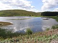
 The middle reaches of the Ale Waters |
||
| Data | ||
| location | Scottish Borders , Scotland | |
| River system | tweed | |
| Drain over | Teviot → Tweed → North Sea | |
| River basin district | Solway Tweed | |
| source | on the slopes of Deep Slack 55 ° 23 ′ 40 ″ N , 3 ° 2 ′ 43 ″ W |
|
| Source height | 363 m ASL | |
| muzzle | At Ancrum in the Teviot coordinates: 55 ° 30 '14 " N , 2 ° 35' 16" W 55 ° 30 '14 " N , 2 ° 35' 16" W.
|
|
| length | 38 km | |
| Reservoirs flowed through | Alemoor Hole | |
The Ale Water is a river in the Scottish Council Area Scottish Borders .
geography
The Ale Water rises at a height of 363 meters on the eastern slope of the Deep Slack , which is referred to in older sources as Henwoodie Hill , in the Ettrick Forest . Initially, it runs in a northeasterly direction for around 30 kilometers. The Ale Water runs through a hilly, sparsely populated region of the Scottish Borders. It affects the villages of Ashkirk and Lilliesleaf . Finally, the ale water gradually turns to the southeast and then, after a run of 38 kilometers, flows into the Teviot at Ancrum , which drains into the North Sea via the Tweed .
The Ale Water to the Alemoor Loch is dammed along the upper course . Numerous streams flow into the Ale Water, especially from the left.
The Alemoor Loch

Mouth of the Ale Waters into the Teviot

