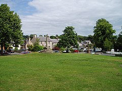
Ancrum
|
Ancrum Scottish Gaelic Alan Crom |
||
|---|---|---|
| Buildings in Ancrum | ||
| Coordinates | 55 ° 31 ′ N , 2 ° 35 ′ W | |
|
|
||
| administration | ||
| Post town | JEDBURGH | |
| ZIP code section | TD8 | |
| prefix | 01835 | |
| Part of the country | Scotland | |
| Council area | Scottish Borders | |
| British Parliament | Berwickshire, Roxburgh and Selkirk | |
| Scottish Parliament | Ettrick, Roxburgh and Berwickshire | |
Ancrum ( Gaelic : Alan Crom ) is a village in the Scottish Council Area Scottish Borders or in the traditional county of Roxburghshire . It is located around five kilometers northwest of Jedburgh and 16 kilometers southeast of Selkirk near the confluence of the Ale Water in the Teviot .
history
The old Gaelic name Alnecrom describes the location of the village at a bend ("crom") of the Ale Water ("Alne"). In the course of history, however, the location of Ancrums shifted several hundred meters to the southeast. To distinguish the settlements, the names Over Ancrum and Nether Ancrum (today's Ancrum) were common in the transition period .
The Scottish King David I founded a small monastery near Ancrum in the 12th century. It was one of the possessions of the Order of Malta . There was a fortified fort near the complex . In the course of the Rough Wooing , Ancrum was completely burned down in the 1540s. At the Battle of Ancrum Moor, Scottish formations under Archibald Douglas, 6th Earl of Angus, defeated returning English troops. In 1639 Over Ancrum was promoted to the status of a Burghs of Banrony .
The Kerr clan built a tower house on the southern edge of Over Ancrum around 1558 . Later the building became the mansion Ancrum House expanded, which was eventually canceled in the 1970s. After completing his civil service in India, Thomas Elliott Ogilvie bought a property near Ancrum in the 1780s. The country villa Chesters House was built there by 1790 .
Between 1961 and 1991, between 266 and 304 people lived in Ancrum.
traffic
The B6400 is the main thoroughfare of Ancrum. It connects the village to the A68 ( Edinburgh - Darlington ) that passes a few hundred meters to the east . The A698 ( Hawick - Berwick-upon-Tweed ) runs along the opposite bank of the Teviot . In the late 18th century, the Old Ancrum Bridge was used to cross the Teviot near Ancrum. With the construction of the new Ancrum Bridge along the A68 a few meters downstream in 1939, the Old Ancrum Bridge became obsolete.
Individual evidence
- ^ List of Gaelic expressions
- ↑ a b c Entry in the Gazetteer for Scotland
- ↑ a b Ancrum in: FH Groome (ed.): Ordnance Gazetteer of Scotland: A Survey of Scottish Topography, Statistical, Biographical and Historical , Grange Publishing Works, Edinburgh, 1882–1885.
- ↑ Entry on Ancrum House in Canmore, the database of Historic Environment Scotland (English)
- ↑ Listed Building - Entry . In: Historic Scotland .
- ^ Information in the Gazetteer for Scotland
- ↑ Listed Building - Entry . In: Historic Scotland .
- ↑ Entry on Ancrum New Bridge in Canmore, the database of Historic Environment Scotland (English)

