Alento
| Alento | ||
|
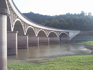
Bridge over the Alento |
||
| Data | ||
| location | Southwest Italy, Campania | |
| River system | Alento | |
| River basin district | Appennino Meridionale | |
| source | Monte Le Corne at Stio 40 ° 18 ′ 12 ″ N , 15 ° 14 ′ 9 ″ E |
|
| Source height | 894 m | |
| muzzle |
Marina di Casalvelino and Elea Coordinates: 40 ° 9 ′ 47 " N , 15 ° 8 ′ 35" E 40 ° 9 ′ 47 " N , 15 ° 8 ′ 35" E |
|
| Mouth height | 0 m | |
| Height difference | 894 m | |
| Bottom slope | 26 ‰ | |
| length | 35 km | |
| Catchment area | 415 km² | |
| Drain |
MQ |
4.35 m³ / s |
| Left tributaries | T. Fiumicello, T. Badolato | |
| Reservoirs flowed through | Alento reservoir | |
The Alento is a river in southwest Italy. In ancient times the river was called Hales .
geography
The Alento rises near the Monte Le Corne near Gorga, a district of Stio in southern Italy . Stio is in the province of Salerno . After a few kilometers it flows through the Alento reservoir. Then it flows south through a valley between the foothills of the Central Massif of the Cilento on the left and Monte Stella on the right and flows into the Tyrrhenian Sea between Marina di Casalvelino and Elea .
Hydrology
The water of the Alento comes mainly from the central Cilento . The average amount of water in this river is about 4.35 m³ per second.
Web links
Commons : Alento - collection of images, videos and audio files

