
Aliveri
|
Aliveri district Δημοτική Κοινότητα Αλιβερίου (Αλιβέρι) |
|||
|---|---|---|---|
|
|||
| Basic data | |||
| Country |
|
||
| region | Central Greece | ||
| Regional district | Euboea | ||
| local community | Kymi-Aliveri | ||
| Parish | Tamynei | ||
| Geographic coordinates | 38 ° 24 ' N , 24 ° 3' E | ||
| Height above d. M. |
23 m (average) |
||
| surface | 33.468 km² | ||
| Residents | 5249 (2011) | ||
| Population density | 156.8 Ew. / km² | ||

Aliveri ( Greek Αλιβέρι ( n. Sg. )) Is a city on the island of Evia . After the incorporation of some smaller villages in 1997, the official name of the city was Dimos Tamyneon (after the former name of the municipality). In 2010 this municipality was merged with four neighboring municipalities to form the new municipality of Kymi-Aliveri , in which Aliveri is the administrative center.
The place is south of Chalkida and Eretria . To the southeast is Dystos Lake . Due to the industrial orientation of the local economy, the construction of tourist facilities was prohibited for a long time. Nevertheless, the place has a number of good pebble beaches, the port of Karavos is now a popular destination in the region, especially because of the numerous fish taverns and nightspots. The old town lies on a hill and is now deserted, today's center is in the valley about 1.5 km from the port of Karavos.
Aliveri power plant
Due to the coal deposits in the area, a coal-fired power plant was built on the outskirts on the coast in 1955 . The deposits were transported from the mountain through the town to the power station on an industrial train. These are now exhausted and the power plant has switched to oil firing.

The church in the old town
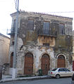
A former commercial building in the old town


Individual evidence
- ↑ Results of the 2011 census at the National Statistical Service of Greece (ΕΛ.ΣΤΑΤ) ( Memento from June 27, 2015 in the Internet Archive ) (Excel document, 2.6 MB)