Alvesrode
|
Alvesrode
City Jump
|
||
|---|---|---|
| Coordinates: 52 ° 12 ′ 7 ″ N , 9 ° 36 ′ 6 ″ E | ||
| Height : | 99 m above sea level NHN | |
| Area : | 4.4 km² | |
| Residents : | 511 (June 30, 2019) | |
| Population density : | 116 inhabitants / km² | |
| Incorporation : | March 1, 1974 | |
| Postal code : | 31832 | |
| Area code : | 05041 | |
|
Location of Alvesrode in Lower Saxony |
||
|
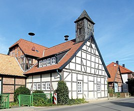
Like its neighboring buildings, the old chapel is considered a monument
|
||
Alvesrode is an eastern part of the town of Springe in Lower Saxony . The place is a bit out of the way in the south of the federal highway 217 .
history
Alvesrode was first mentioned in a document in 1250 as "Zum Rohde". The name indicates its origin as a -rode settlement. It was not until 1561 that the place name changed to "Alversrohde" and later also to "Alfesrod", "Albesroe" and "Alfesroda".
Alvesrode has been part of the town of Springe since the regional reform that came into force on March 1, 1974.
politics
The local mayor is Dieter Gonschorek (CDU).
Architectural monuments
Web links
Individual evidence
- ^ Federal Statistical Office (ed.): Official municipality directory for the Federal Republic of Germany. Final results after the census of September 13, 1950 (= Statistics of the Federal Republic of Germany . Volume 33 ). W. Kohlhammer, Stuttgart / Cologne 1952, p. 32 ( digital version [PDF; 27.1 MB ]).
- ^ Districts of the city of Springe. In: Website of the city of Springe. June 30, 2019. Retrieved October 20, 2019 .
- ↑ Chronicle Alvesrode
- ^ Federal Statistical Office (ed.): Historical municipality directory for the Federal Republic of Germany. Name, border and key number changes in municipalities, counties and administrative districts from May 27, 1970 to December 31, 1982 . W. Kohlhammer, Stuttgart / Mainz 1983, ISBN 3-17-003263-1 , p. 203 .
- ↑ Alvesrode Local Councilor


