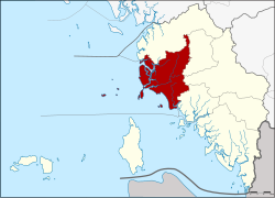
Amphoe La-ngu
|
La-ngu ละงู |
|
|---|---|
| Province: | Satun |
| Surface: | 380.35 km² |
| Residents: | 69,313 (2012) |
| Population density : | 168.1 U / km² |
| ZIP : | 91110 |
| Geocode : | 9105 |
| map | |

|
|
Amphoe La-ngu ( Thai : อำเภอ ละงู ) is a district ( amphoe - administrative district) in the province of Satun . Satun Province is located in the west of the southern region of Thailand on the west coast of the Malay Peninsula .
geography
Neighboring counties and areas are (clockwise from north): Thung Wa , Manang , Khuan Kalong and Tha Phae . All Amphoe are in the Satun Province. To the west lies the Strait of Malacca .
A large part of the coast of the district as well as some offshore islands are part of the Mu Ko Phetra National Park and the Tarutao National Park .
history
La-ngu was one of the three original districts of Satun , it was initially a small district ( King Amphoe ) under the administration of Thung Wa. When pepper production in Thung Wa declined in the 1910s, many locals moved to the agricultural district by La-ngu. In 1930 the government adapted the administration to the changed economic situation by upgrading La-ngu to a district and at the same time transforming Thung Wa into a small district. The original seven tambon were reduced to five in 1944. A sixth tambon was set up on August 1, 1978.
administration
Provincial Administration
Amphoe La-ngu is divided into six sub-districts ( tambon ) , which are further subdivided into 64 village communities ( muban ) .
| No. | Surname | Thai | Muban | Pop. |
|---|---|---|---|---|
| 1. | Kamphaeng | กำแพง | 12 | 18,168 |
| 2. | La-ngu | ละงู | 18th | 21,641 |
| 3. | Khao Khao | เขา ขาว | 7th | 6,390 |
| 4th | Pak Nam | ปากน้ำ | 11 | 10,395 |
| 5. | Nam Phut | น้ำ ผุด | 6th | 9,060 |
| 6th | Laem Son | แหลม สน | 10 | 3,659 |
Local administration
Kamphaeng ( เทศบาล ตำบล กำแพง ) is a small town ( Thesaban Tambon ) in the district, it consists of parts of the Tambon Kamphaeng.
There are also six “tambon administration organizations” (TAO, องค์การ บริหาร ส่วน ตำบล ) for the tambon or the parts of tambon in the county that do not belong to any town.
Individual evidence
- ↑ ประกาศ กระทรวง มหาดไทย เรื่อง ย้าย สับเปลี่ยน ที่ว่าการ อำเภอ . In: Royal Gazette . 47, No. 0 ก , September 14, 1930, p. 193.
- ↑ ข้อมูล ทั่วไป ( Thai ) La-ngu police station. Retrieved July 13, 2014.
- ↑ ประกาศ กระทรวง มหาดไทย เรื่อง ตั้ง และ เปลี่ยนแปลง เขต ตำบล ใน ท้องที่ อำเภอ ละงู จังหวัด สตูล Royal Gazette, Volume 95, Issue 95 ง of September 12, 1978, pp. 2966-2968 (in Thai)
- ↑ Population statistics 2012 . Department of Provincial Administration. Retrieved July 13, 2014.
Web links
Coordinates: 6 ° 52 ' N , 99 ° 48' E
