Ankerbach (White Valepp)
| Ankerbach | ||
|
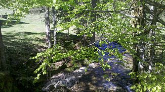
Ankerbach at the confluence with the White Valepp at the Valeppalm |
||
| Data | ||
| location | Upper Bavaria | |
| River system | Danube | |
| Drain over | White Valepp → Valepp → Grundache → Brandenberger Ache → Inn → Danube → Black Sea | |
| source | West slope of Stolzenberg 47 ° 38 '54 " N , 11 ° 51' 53" E |
|
| Source height | 1542 m | |
| muzzle |
White Valepp Coordinates: 47 ° 37 '59 " N , 11 ° 51' 12" E 47 ° 37 '59 " N , 11 ° 51' 12" E |
|
| Mouth height | 952 m | |
| Height difference | 590 m | |
| Bottom slope | approx. 22% | |
| length | approx. 2.7 km | |
| Catchment area | 4.1 km² | |
The Ankerbach is a tributary of the White Valepp in Upper Bavaria .
geography
course
The Ankerbach forms in ditches on the western slopes between Stolzenberg and Rotkopf . It then flows past the Ankerstube and joins the White Valepp from the left at the Valeppalm .
Tributaries
Selection.
- Stümpflinggraben, from the right just before the Ankerstube, approx. 1.6 km
- Stolzentalgraben, from the left and west shortly after the Ankerstube, approx. 1.7 km
Individual evidence
Web links
- [1] The course of the Ankerbach on the BayernAtlas
