Ankerbach (Rhine)
| Ankerbach | ||
|
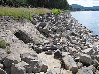
Exit of the Ankerbach on the Rhine. |
||
| Data | ||
| Water code | DE : 27197112 | |
| location | Bonn , North Rhine-Westphalia , Germany | |
| River system | Rhine | |
| Drain over | Rhine → North Sea | |
| source | South-east of Oberholtorf 50 ° 43 '26 " N , 7 ° 11' 20" E |
|
| Source height | 166 m above sea level NHN | |
| muzzle | In the Rhine (km 650.55) coordinates: 50 ° 42 '56 " N , 7 ° 9' 20" O 50 ° 42 '56 " N , 7 ° 9' 20" O |
|
| Mouth height | 56 m above sea level NHN | |
| Height difference | 110 m | |
| Bottom slope | 25 ‰ | |
| length | 4.4 km | |
| Catchment area | 3 km² | |
| Left tributaries | Peschsiefen | |
| Big cities | Bonn | |
|
The Ankerbach before crossing under the Oberkasseler Ufer. |
||
The Ankerbach is a brook in Bonn , district of Beuel . Its total length is 4.4 kilometers and its catchment area is 3.0 square kilometers.
course
In the upper reaches of a forest area, the stream is a near-natural body of water with a rich flora of Mullboden herb flora and seepage spring areas. In the settlement area, it is a moderately natural body of water. It flows south of the area of the former cement factory (Bonner Bogen) near Oberkassel into the Rhine.
Web links
Commons : Ankerbach - Collection of Images
Individual evidence
- ↑ a b German basic map 1: 5000
- ↑ Water directory of the State Office for Nature, Environment and Consumer Protection NRW 2010 (XLS; 4.67 MB) ( Notes )
- ↑ Bach Development Plan 2008 , City of Bonn (PDF; 1.65 MB)

