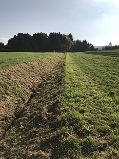
Peschsiefen
| Peschsiefen | ||
| Data | ||
| Water code | DE : 271971122 | |
| location | Bonn , North Rhine-Westphalia , Germany | |
| River system | Rhine | |
| Drain over | Ankerbach → Rhine → North Sea | |
| source | south of Oberholtorf 50 ° 43 ′ 10 ″ N , 7 ° 11 ′ 12 ″ E |
|
| Source height | approx. 177 m above sea level NHN | |
| muzzle | In the Ankerbach northwest of Oberholtorf Coordinates: 50 ° 43 '39 " N , 7 ° 10' 50" E 50 ° 43 '39 " N , 7 ° 10' 50" E |
|
| Mouth height | approx. 136 m above sea level NHN | |
| Height difference | approx. 41 m | |
| Bottom slope | approx. 36 ‰ | |
| length | 1.1 km | |
| Catchment area | 70 ha | |
| Big cities | Bonn | |
The Peschsiefen is a brook in Bonn , district of Beuel . Its total length is 1.13 kilometers and its catchment area is 0.7 square kilometers.
course
The brook is a trench-like river in a heavily used agricultural area. Accompanying wood on the banks is missing.
Individual evidence
- ↑ a b German basic map 1: 5000
- ↑ a b Bach Development Plan 2008 , City of Bonn (PDF; 1.65 MB)
