Antelope (Oregon)
| Antelope | |
|---|---|
|
Location in county and Oregon
|
|
| Basic data | |
| Foundation : | 1901 |
| State : | United States |
| State : | Oregon |
| County : | Wasco County |
| Coordinates : | 44 ° 55 ′ N , 120 ° 43 ′ W |
| Time zone : | Pacific ( UTC − 8 / −7 ) |
| Residents : | 46 (as of 2010) |
| Population density : | 35.4 inhabitants per km 2 |
| Area : | 1.3 km 2 (approx. 1 mi 2 ) of which 1.3 km 2 (approx. 1 mi 2 ) is land |
| Height : | 818 m |
| FIPS : | 41-02250 |
| GNIS ID : | 1116966 |
| Mayor : | Brian Sheer |
Antelope is an American village in Wasco County in the state of Oregon . Between 1984 and 1985 the place was named Rajneesh .
geography
Antelope lies at an altitude of 818 m and covers an area of 1.3 km² .
Residents
In 2010 there were 46 inhabitants in 27 households in Antelope.
history
The village of Antelope was the first village in the valley of the same name in which many pronghorns (American English: "Antelopes") grazed. In 1871 the village received a post office and became a stagecoach stop where travelers could rest and spend the night. Over time, the settlement became a center of cattle and sheep breeding, and had its share of western town shootings in the 1890s. Like many other small towns during this period, Antelope was destroyed by fire in 1898. Only one building on the main street survived the fire and you can still see it today. The city was rebuilt, but lost its importance when a new city called Shaniko was built a few miles north on the railway line .
Rajneeshpuram
Antelope became known in 1981 when the followers of Bhagwan Shree Rajneesh settled at the Big Muddy Ranch under the leadership of Ma Anand Sheela .
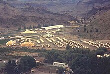
The Ashram Rajneeshpuram ("City of Rajneesh") housed 3,000 inhabitants in 1983, 7,000 inhabitants in 1985 and had its own airfield ( 44 ° 49 ′ 43 ″ N , 120 ° 29 ′ 44 ″ W ) and a 60 × 130 m large assembly hall 44 ° 50 ′ 13 ″ N , 120 ° 28 ′ 34 ″ W ( Mandir ).
The red-clad Bhagwan followers, called sannyasins , populated the barren landscape. The Puram got its own post office, school, fire and police department, shopping centers, restaurants and a public transport system with 85 buses. Its water storage tank with a capacity of 1,323 million liters won an award for its innovative, environmentally friendly construction, and its own power station supplied the city with the electricity it needed. The Sanyassins purposefully bought real estate in order to achieve a majority in the city council, which they succeeded. On September 18, 1984, the village of Antelope was renamed Rajneesh with a 57-22 vote .
As a result, numerous scandals such as a bioterrorism attack became public, and Bhagwan's “right hand man” Sheela fled. Baghwan broke with her publicly and announced the renaming of the city; he fled and was arrested on October 28, 1985. Then the Rajneeshpuram collapsed. On November 6, 1985, the city council voted 34 to 0 to rename the settlement Antelope.
Big Muddy Ranch
This ranch was formerly the location of Wild West films starring John Wayne .
Today it belongs to the Christian youth organization Young Life and part of the former city of Rajneeshpuram is a youth camp called "Washington Family Ranch".
In 2003, 2004 and 2006 international orienteering competitions took place on the site .
Web links
- Website of Antelope (English)
- Big Muddy Ranch Airport
Footnotes
- ↑ US Census Bureau: American FactFinder - Community Facts. Accessed June 5, 2018 .
- ↑ https://washingtonfamilyranch.younglife.org/

