Arbesthal
|
Arbesthal ( village ) locality cadastral municipality Arbesthal |
||
|---|---|---|
|
|
||
| Basic data | ||
| Pole. District , state | Bruck an der Leitha (BL), Lower Austria | |
| Judicial district | Bruck an der Leitha | |
| Pole. local community | Göttlesbrunn-Arbesthal | |
| Coordinates | 48 ° 3 '46 " N , 16 ° 42' 25" E | |
| height | 172 m above sea level A. | |
| Residents of the village | 523 (January 1, 2020) | |
| Area d. KG | 9.48 km² | |
| Statistical identification | ||
| Locality code | 03453 | |
| Cadastral parish number | 05001 | |
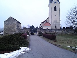
 Cemetery with a former castle complex |
||
| Source: STAT : index of places ; BEV : GEONAM ; NÖGIS | ||
Arbesthal is a village and a cadastral municipality in the municipality of Göttlesbrunn-Arbesthal in Lower Austria.
Arbesthal is located northwest of the town of Bruck an der Leitha, 6 km away, and is located north on the Ost Autobahn in the immediate vicinity of the Göttlesbrunn service station .
In 1083 the place appears for the first time under the name Arawezital . The monastery of Göttweig ruled Arbesthal , but the place was reformed from Trautmannsdorf during the Reformation and was Protestant until 1584. During the retreat during the first Turkish siege in 1529, the residents fled to the northern forest and Arbesthal was devastated. The same fate befell the villages during the Turkish campaign of 1683. In 1835 the village is mentioned with 67 houses and 390 inhabitants who grow grain and some wine.
Individual evidence
- ^ History. goettlesbrunn-arbesthal.gv.at, accessed on September 23, 2018 .
- ^ Wenzel Carl Wolfgang Blumenbach : Arbesthal . In: The latest regional studies of Austria under the Ens . tape 2 . Verlag Carl Reichard, Güns 1835, p. 264 ( reader.digitale-sammlungen.de ).
