Argi
|
Argi Арги |
||
|
|
||
| Data | ||
| Water code | RU : 20030400112118100024282 | |
| location | Amur Oblast ( Russia ) | |
| River system | Amur | |
| Drain over | Seja → Amur → Tatar Sound | |
| source | in the eastern Stanowoy Mountains 54 ° 37 ′ 45 ″ N , 131 ° 8 ′ 51 ″ E |
|
| muzzle |
Seja coordinates: 54 ° 41 ′ 36 " N , 129 ° 4 ′ 3" E 54 ° 41 ′ 36 " N , 129 ° 4 ′ 3" E
|
|
| length | 350 km | |
| Catchment area | 7090 km² | |
|
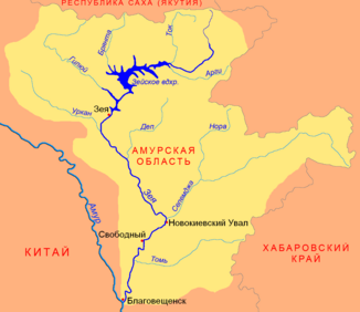
Location of the Agri (Арги) in the catchment area of the Seja |
||
The Argi ( Russian Арги ) is a left tributary of the Seja in the Amur Oblast in the Far East of Russia .
The Argi has its source in the eastern Stanowoy Mountains . From there the river flows through the Upper Seja Plain ( Верхнезейская равнина ) in a westerly direction and after 350 km it flows on the left into the Seja, immediately before it flows into the Seja Reservoir . It drains an area of 7090 km². Every year from April to September the river has floods .
Individual evidence
- ↑ a b c Article Argi in the Great Soviet Encyclopedia (BSE) , 3rd edition 1969–1978 (Russian)
- ↑ a b Argi in the State Water Directory of the Russian Federation (Russian)
