Armadale (Western Australia)
| Armadale | |||||||
|---|---|---|---|---|---|---|---|
|
|||||||
|
|||||||
|
|||||||
|
|||||||
|
|
|||||||
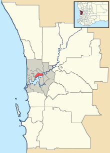
Armadale is a city with less than 14,000 inhabitants (2016) in the Australian state of Western Australia . It is located 27 kilometers southeast of the center of the capital Perth and is therefore on the edge of the metropolitan region. In the center of Armadale two main roads meet, the South Western and the Albany Highway , which connect the south of the state with Perth. Armadale is the seat of the eponymous administrative area (LGA) City of Armadale .
In the center of the city there is an unusually large and old Eucalyptus marginata tree, the Old Jarrah Tree . Its age is estimated to be 400 to 800 years. Due to extensive forestry and deforestation in the Perth area in the 19th century, such trees are rare.
sons and daughters of the town
- Brad Jones (born 1982), football player
Web links
Commons : Armadale, Western Australia - Collection of pictures, videos and audio files
Individual evidence
- ↑ Australian Bureau of Statistics : Armadale (State Suburb) ( English ) In: 2016 Census QuickStats . June 27, 2017. Retrieved April 12, 2020.

