Aschler Bach
|
Aschler Bach Plattenbach, Gargazoner Bach, Rio Eschio |
||
|
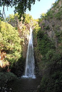
Waterfall on the lower reaches |
||
| Data | ||
| location | South Tyrol , Italy | |
| River system | Etsch | |
| Drain over | Adige → Adriatic Sea | |
| source | at Auener Jöchl 46 ° 38 '42 " N , 11 ° 17' 42" O |
|
| muzzle | at Gargazon in the Adige Coordinates: 46 ° 35 ′ 10 " N , 11 ° 11 ′ 20" E 46 ° 35 ′ 10 " N , 11 ° 11 ′ 20" E |
|
| Mouth height |
255 m slm
|
|
| length | 13.3 km | |
| Catchment area | 29 km² | |
| Right tributaries | Verano brook | |
The Aschler Bach (also called Plattenbach in its upper course , Gargazoner Bach in its lower course ; in Italian rio Eschio ) is a brook that flows into the Etsch from the left in the Sarntal Alps in South Tyrol .
geography
The Aschler Bach rises at the Auener Jöchl on the Tschögglberg at an altitude of around 1900 m . On its approximately 13.3 km long, approximately south-western route, it is the long border of the municipalities of Vöran , Mölten , Burgstall and Gargazon . At its middle course it flows past the eponymous hamlet of Aschl . Further down the stream it reaches its most important tributary from the right, the Vöran stream . At Gargazon, the only village through which the Aschler Bach flows, it reaches the Etsch Valley , where it flows into the Etsch at an altitude of 255 m .
Individual evidence
- ↑ a b Geobrowser of the Autonomous Province of Bolzano - South Tyrol
- ^ Aschler Bach on the website of the South Tyrolean Environment Agency
