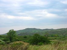
Azov highlands
The Azov Highlands ( Ukrainian Приазовська височина Pryasowska vyssotschyna ; Russian Приазовская возвышенность Priasowskaja voswyshenost ) is a highland north of the Sea of Azov in the southeast of the Ukraine .
The highlands are part of the Ukrainian shield and headwaters of some rivers that flow into the Sea of Azov, such as the Molotschna , Berda , Obytitschna , the Kaltschyk ( Кальчик ) flowing into the Kalmius and the Kinska flowing to the Dnepr . The highest elevation of the Azov highlands is the 324 m high Belmak-Mohyla ( Бельмак-Могила ⊙ ) near the village of Trudowe ( Трудове ) near Bilmak . The Azov Highlands are located in the east of Zaporizhia Oblast and in the southwest of Donetsk Oblast and border on the Northeast with the Donetsk Plateau and in the south and west with the Black Sea lowlands . Parts of the highlands are under nature protection.
Individual evidence
- ^ Azov Highlands in the Encyclopedia of Ukraine , accessed January 21, 2015
- ^ Azov Highlands in the Encyclopædia Britannica , accessed January 21, 2015
- ^ Azov Highlands in the Great Soviet Encyclopedia of 1979 , accessed January 21, 2015
Coordinates: 47 ° 20 ' N , 36 ° 35' E

