Kalmius
|
Kalmius Кальміус, Кальмиус |
||
|
Course of the river within Donetsk Oblast |
||
| Data | ||
| location | Donetsk Oblast ( Ukraine ) | |
| River system | Kalmius | |
| source | in Yassynuwata (north of Donetsk ) 48 ° 7 ′ 10 ″ N , 37 ° 52 ′ 11 ″ E |
|
| muzzle | near Mariupol in the Sea of Azov Coordinates: 47 ° 5 '10 " N , 37 ° 34' 32" E 47 ° 5 '10 " N , 37 ° 34' 32" E
|
|
| length | 209 km | |
| Catchment area | 5070 km² | |
| Drain |
MQ |
6.23 m³ / s |
| Right tributaries | Kaltschyk | |
| Big cities | Donetsk , Mariupol | |
| Small towns | Komsomolske , Sartana | |
|
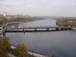
Kalmius in Donetsk |
||
Kalmius ( Ukrainian Кальміус ; Russian Кальмиус ) is a 209 km long, eastern Ukrainian river.
It rises near the city of Yasynuwata , north of Donetsk , and flows into the Sea of Azov in Mariupol . In Mariupol the Kaltschyk meets the Kalmius from the right. Within the urban area of Donetsk, the Kalmius is dammed up to form an elongated lake, which is important for the microclimate of this large industrial metropolis located in the steppe . The Kalmius drains an area of 5070 km². The mean discharge is 6.23 m³ / s.
The river used to be called Kalka . The Battle of the Kalka in 1223 took place near the river.
Web links
Commons : Kalmius - collection of images, videos and audio files

