
Asserballe Station
|
Asserballe Station ( German Adserballe St. ) |
|||||
|
|||||
| Basic data | |||||
|---|---|---|---|---|---|
| State : |
|
||||
| Region : | Syddanmark | ||||
|
Municipality (since 2007) : |
Sønderborg | ||||
| Municipality / Office : (until the end of 2006) |
Augustenborg Municipality Sønderjyllands Amt |
||||
| Sogn : | Asserballe Sogn | ||||
| Coordinates : | 54 ° 58 ' N , 9 ° 55' E | ||||
| Founded: | 1897 | ||||
| Postal code : | 6440 Augustenborg | ||||
| Website: | www.sonderborg.dk | ||||
 Former train station and feed trade |
|||||


Asserballe Station is a settlement on the Danish island of Als , four kilometers northeast of Augustenborg and four kilometers southwest of Fynshav on Primærrute 8. The settlement belongs to Sønderborg Municipality and is located in the Syddanmark region . It belongs to the Asserballe Sogn . The Asserballe Kirke is located in Asserballe , two kilometers to the east.
history
The settlement was built around Asserballe train station, which was built in 1897 from the circular railway on Alsen next to the lonely poor house ( Fattiggården in Danish ) built in 1869 . It is referred to as a hospital on the Prussian measurement table . In 1873, 19 poor people from the surrounding communities were taken in; in 1899 there were 9.
The station had a locomotive shed, but was only referred to as a stop ( Danish trinbræt ) on the German map . The stop was the only one in Asserballe Sogn and was named after the community. The railway line was opened on February 6, 1898. A grain and feed trade was housed in the station building. Part of the station burned down in 1931, but was rebuilt.
Amtsbanerne på Als ceased operations on the line on February 28, 1933. The engine shed no longer exists, the foundation can still be seen. A 1½ km long footpath and cycle path to Hundslev starts 400 m north of the station and runs along the longest section of the embankment, which has been preserved by the Amtsbanerne på Als, with the exception of sections within Sønderborg where the embankment of the divested Sønderborg– Mommark has been reused.
photos

Foundation of the engine shed
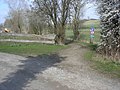
Hiking trail to Hundslev (railway embankment)


Web links
- Fotoarkiv Asserballe Station. In: Lokalhistorisk Arkiv, Augustenborg. Accessed February 1, 2020 .
- SDFE kortviser. Retrieved on February 2, 2020 (Danish, cat viewer, allows old maps to be viewed, such as the Prussian measuring table sheet 1877–1920 and a Danish map 1920–71).
Individual evidence
- ^ Anne Marie Jacobsen, Birgit Weitling: Fattiggårde på landet i Sønderjylland . Sønderjylland Museum, Haderslev 2008 (Danish).