Astor (river)
| Astor | ||
|
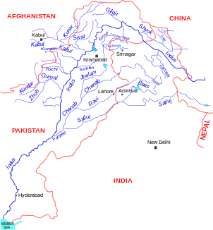
Location of the Astor in the river system of the Indus; The Astor flows into the Indus below the Gilgit |
||
| Data | ||
| location | Gilgit-Baltistan ( Pakistan ) | |
| River system | Indus | |
| Drain over | Indus → Indian Ocean | |
| source | west of the Burzil Pass 34 ° 54 ′ 9 ″ N , 75 ° 4 ′ 31 ″ E |
|
| Source height | approx. 4200 m | |
| muzzle |
Indus coordinates: 35 ° 34 ′ 12 " N , 74 ° 38 ′ 42" E 35 ° 34 ′ 12 " N , 74 ° 38 ′ 42" E |
|
| Mouth height | approx. 1200 m | |
| Height difference | approx. 3000 m | |
| Bottom slope | approx. 25 ‰ | |
| length | 120 km | |
| Catchment area | 5092 km² | |
| Left tributaries | Amri Gah, Ratu | |
| Right tributaries | Ramghat Gah | |
| Small towns | Astore | |
| Communities | Gorikot | |
| Residents in the catchment area | 72000 | |
|
Astor at Hurcho |
||
The Astor is a left tributary of the Indus in the south of the Pakistani special territory Gilgit-Baltistan .
The Astor rises west of the Burzil Pass in the western Himalayas . The river flows north. It drains the south and east flanks of the Nanga Parbat massif and the west of the Deosai plateau . At the village of Gorikot the Ratu flows into the Astor from the left. Shortly thereafter, the Astor passes the Astortal's administrative center, Astore . The Astor flows another 40 km north to its confluence with the Indus, 12 km south of the city of Juglot . The Astor Valley Road runs the length of the river. The Astor has a length of 120 km. The catchment area of the Astor is congruent with the Astore district .

