
Aubach (Kinsach)
| Aubach | ||
 It flows into the Kinsach near Wolferszell |
||
| Data | ||
| Water code | DE : 158392 | |
| location | Bavaria | |
| River system | Danube | |
| Drain over | Kinsach → Danube → Black Sea | |
| source |
Einfürst (Mitterfels) 48 ° 59 ′ 22 ″ N , 12 ° 40 ′ 3 ″ E |
|
| Source height | approx. 435 m above sea level NN | |
| muzzle | West of Wolferszell Coordinates: 48 ° 58 '1 " N , 12 ° 38' 42" E 48 ° 58 '1 " N , 12 ° 38' 42" E |
|
| Mouth height | approx. 328 m above sea level NN | |
| Height difference | approx. 107 m | |
| Bottom slope | approx. 23 ‰ | |
| length | 4.7 km | |
| Catchment area | 4.24 km² | |
| Left tributaries | Reinbach (Aubach) | |
| Communities | Mitterfels , Ascha | |
The Aubach is a left, eastern tributary of the Kinsach in the Straubing-Bogen district in Lower Bavaria .
course
The Aubach flows from its almost entirely wooded headwaters south of Einfürst, viewed on a large scale, first to the south and then for a short distance between Großkohlham on the right and Kleinkohlham on the left edge hill completely out of the forest. Further south and in the valley forest - or at least bounded on one side by hillside forest - it flows past Miething on the right on the height and then Spornhüttling on a left mouth spur. Then it bends west for about 600 meters.
After this stretch, its most important tributary stream from a forest valley from the north flows to it from the right below the Fuchsberg- Sporn, with a length of approximately 1.2 kilometers. Here it finally turns to the south-west and only emerges from the valley forest again below the Auhof , which stands on a low right hill . After having passed a narrow gap between forest slopes down to the valley floor about 600 meters further, it enters the moss from the wider valley level east of Wolferszell and then flows in the area of an eastern loop of the river from the left into the Kinsach , which faces south on a large scale running.
The Aubach drains an area of 4.24 square kilometers, of which about 4.13 square kilometers are the municipality of the Mitterfels market.
gallery

Headwaters at Einfürst

Bachaue near Auhof
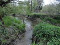
Estuary into the Kinsach
_Quellgebiet_bei_Einf%C3%BCrst_(Mitterfels).JPG)
_bei_Auhof_(Mitterfels).JPG)
Web links
- Catchment area of the Aubach. Bavarian State Office for the Environment, accessed on April 28, 2014 .
Individual evidence
- ↑ BayernAtlas - headwaters of the Aubach. State Office for Digitization, Broadband and Surveying, accessed on April 28, 2014 .
- ↑ BayernAtlas - mouth of the Aubach. State Office for Digitization, Broadband and Surveying, accessed on April 28, 2014 .
- ↑ a b List of brook and river areas in Bavaria - Danube river area from Naab to Isar. (pdf; 2.7 MB) Bavarian State Office for the Environment, accessed on April 20, 2014 .
- ↑ Measured on: BayernAtlas of the Bavarian State Government ( notes )