Auerbach (Bessenbach)
|
Auerbach ( Historically : Keilbach ) |
||
|
The Auerbach in Keilberg |
||
| Data | ||
| location |
Spessart
|
|
| River system | Rhine | |
| Drain over | Bessenbach → Aschaff → Main → Rhine → North Sea | |
| source | south of Waldaschaff 49 ° 57 ′ 55 ″ N , 9 ° 17 ′ 3 ″ E |
|
| Source height | 283 m above sea level NHN | |
| muzzle | in Keiberg in den Bessenbach Coordinates: 49 ° 58 ′ 39 " N , 9 ° 15 ′ 17" E 49 ° 58 ′ 39 " N , 9 ° 15 ′ 17" E |
|
| Mouth height | 165 m above sea level NHN | |
| Height difference | 118 m | |
| Bottom slope | 44 ‰ | |
| length | 2.7 km | |
| Catchment area | 2.1 km² | |
The Auerbach is a right tributary of the Bessenbach in the district of Aschaffenburg in the Bavarian Spessart .
geography
course
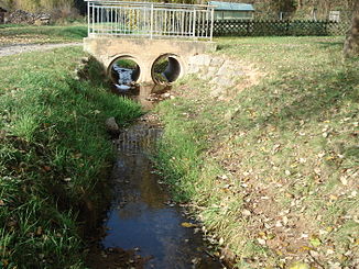
The Auerbach rises on the Birkenberg (418 m), south of Waldaschaff and flows through the Keilberger Wiesengrund in a north-west direction to Keilberg . There it flows into the Bessenbach, piped on the premises of SAF-HOLLAND GmbH .
Aschaff river system
See also
Web links
Commons : Auerbach - collection of images, videos and audio files
