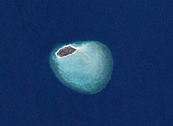
Aukane Island
| Aukane Island | |
|---|---|
| Landsat image of Aukane Island | |
| Waters | Pacific Ocean |
| Archipelago | Bourke Islands |
| Geographical location | 9 ° 52 '9 " S , 143 ° 23' 37" E |
| length | 800 m |
| width | 350 m |
| surface | 20 ha |
| Highest elevation | 9 m |
| Residents | uninhabited |
Aukane Island , also called Aukane Islet , is a small, sparsely vegetated coral island in the northeast of the archipelago of the Torres Strait Islands . The uninhabited island is 800 meters long, about 350 meters wide and is located on the northwestern edge of an approximately four square kilometer, almost circular reef platform .
The island is located nine kilometers east of Layoak Island and 9.5 kilometers north of Mimi Island . It belongs to the group of the Bourke Islands , which administratively belong to the Central Islands , an island region in the Torres Shire administrative district of the Australian state of Queensland .
See also
Individual evidence
- ↑ - ( Memento of the original from October 6, 2014 in the Internet Archive ) Info: The archive link was inserted automatically and has not yet been checked. Please check the original and archive link according to the instructions and then remove this notice.
