
Avenue Raymond Poincare
Coordinates: 48 ° 52 ' N , 2 ° 17' E
| Avenue Raymond Poincare | |
|---|---|
| location | |
| Arrondissement | 16. |
| quarter | Porte Dauphine Chaillot |
| Beginning | Place du Trocadéro-et-du-11-Novembre |
| The End | 39, Avenue Foch |
| morphology | |
| length | 950 m |
| width | 23.5 |
| history | |
| designation | 1936 |
| Original names | Route départementale 9 avenue Saint-Denis avenue de Malakoff |
| Coding | |
| Paris | 8065 |

The Avenue Raymond Poincaré is a 950 meter long and 23.5 meter wide street in the 16th arrondissement of Paris .
location
The street starts at number 6, Place du Trocadéro-et-du-11-Novembre and ends at number 39, Avenue Foch . The Avenue Raymond Poincaré, together with the Avenue de Malakoff to the north of Avenue Foch, forms the border between the Porte Dauphine quarters in the west and Chaillot in the east.

Name origin
The street is named after the politician Raymond Poincaré (1860–1934), who was President of France from 1913 to 1920 .
history
The avenue Raymond-Poincaré, like the entire district of the Plaine de Passy , was not built until the 1850s, after the avenue de l'Impératrice , today's avenue Foch , and the Ligne d'Auteuil with the Porte-Dauphine train station opened in 1854 according to the mid-century plans, which show the development limited to the southeastern part of the avenue.

Residential development on Plaine de Passy from 1825
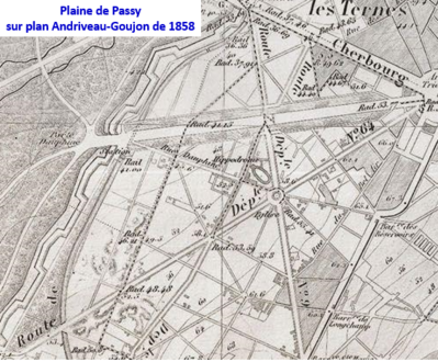
Plaine de Passy in 1858


Attractions
- No. 13: Embassy of Uganda
- No. 27: Apartment of the former President of the French Senate , Gaston Monnerville
- No. 55–57 Luxury hotel Le Parc Trocadéro belonging to the Marriott Group
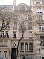
- No. 61–63: Art Deco style building (1928)
- No. 62: Apartment of the writer and painter Jean Cocteau (1889–1963)
- No. 66: Église Saint-Honoré-d'Eylau
- No. 102: Embassy of the Republic of Côte d'Ivoire
- No. 104: Embassy of Georgia
- No. 101–105: Home of the US dental surgeon Thomas W. Evans (1823–1897).
Embassy of Uganda

Memorial plaque to Gaston Monnerville

Art Deco style building

Relief at no. 61–65
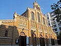
Église Saint-Honoré-d'Eylau

Embassy of the Ivory Coast


7.JPG)
