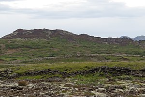
Búrfell upp af Hafnarfirði
| Búrfell upp af Hafnarfirði | ||
|---|---|---|
|
Búrfell above Hafnarfjörður |
||
| height | 180 m | |
| location | Southwest Iceland | |
| Coordinates | 64 ° 1 ′ 57 " N , 21 ° 50 ′ 0" W | |
|
|
||
| Type | Welding slag cone | |
| rock | Olivine basalt v. a. | |
| Age of the rock | approx. 7,200 years | |
| Last eruption | 7,200 years ago | |
| particularities | Búrfellsgjá, approx. 3.5 km long lava channel starting from the crater | |
The volcano Búrfell upp af Hafnarfirði ( Búrfell above Hafnarfjörður ) - also Búrfell (Kjós) - is, as the Icelandic name suggests, above the town of Hafnarfjörður in the southwest of Iceland . It reaches a height of 180 m.
location
The Holocene crater is 7.5 km east-southeast from the town of Hafnarfjörður.
geology
Craters and lava fields
It is a crater that belongs to the active volcanic system Krýsuvík . It last erupted 7,200 years ago. The mainly effusive eruption produced significant amounts of olivine basalt lava . These streamed into the sea in the fjords Hafnarfjörður and Skerjafjörður , covering an area of 18 km² between Hafnarfjörður and Garðabær . A large part of today's town of Hafnarfjörður stands on these lavas.
The lava fields have different names such as Gálgahraun (near Álftanes, because there was a gallows at the time of Pietism in the 17th and 18th centuries), Hafnarfjarðahraun, Gráhelluhraun etc., but are all called Búrfellshraun because of their common origin.
Búrfellsgjá
A particularly long lava channel of 3.5 km is now open as a small gorge called Búrfellsgjá and leads from the crater in an arc down into the valley. It is under nature protection together with the crater.
Ditches and faults
The area is crossed by numerous faults and distortions , that is, by the continental drift -related columns. Overall, these form a long rift that runs through a large part of southwest Iceland, namely from Krýsuvík to the Úlfarsfell . Part of the Búrfellsgjá lies in this trench.
Hiking on the Búrfell
A hiking trail leads up the mountain and through the gorge.
You drive past Vífilsstaðir and into Heiðmörk, where there is a parking lot for hikers at Hjallaendi. From there the easily visible 5 km long hiking trail is signposted. In the lower part in the Búrfellsgjá it is also wide, later it becomes a path.
On the way through the gorge you will pass an old walled-up sheep pen , a rétt . There is a small fountain by this, which explains the complex. On the north side of the Reykjanes Peninsula, water can generally only be found in the depths, the upper rock layers are very permeable to water.
See also
Web links
- Photos and isl. Description of the hike ( memento from August 1, 2009 in the Internet Archive )
- Photos, isl. Text with information about the area
Individual evidence
- ↑ Íslandshandbókin. Náttúra, saga og sérkenni. 2. bindi. Edited by T. Einarsson, H. Magnússon. Reykjavík (Örn og Örlygur) 1989, p. 967
- ↑ a b Íslandshandbókin. Náttúra, saga og sérkenni. 1. bindi. Edited by T. Einarsson, H. Magnússon. Reykjavík (Örn og Örlygur) 1989, p. 74
- ↑ Thor Thordarson, Armann Hoskuldsson: "Iceland (Classic Geology in Europe 3)". Terra Publishing, Harpenden, 2007, ISBN 1-903544-06-8 page 60f
- ↑ a b c Archive link ( Memento of the original dated May 16, 2016 in the Internet Archive ) Info: The archive link was inserted automatically and has not yet been checked. Please check the original and archive link according to the instructions and then remove this notice. T. Einarsson: Búrfell og Búrfellsgjá. Ferðafélag Íslands. Accessed: April 24, 2011 [PDF file] (Icelandic)
- ↑ cf. z. B. also Ari Trausti Guðmundsson: Living Earth. Facets of the geology of Iceland. Reykjavík (Mál og Menning) 2007, p. 122f.
- ↑ http://web.mac.com/sigurdursig/iWeb/EF30423D-5DDF-4AA9-BD8E-9B76D5AD8751/BC815DC2-C094-46DB-950D-00D1A2201438/C8286D86-3DCC-407F-9C8D-352B5E5E310B.html ( memento from 1 August 2009 in the Internet Archive ) Búrfell og Búrfellsgjá. Accessed April 24, 2011 (Icelandic)

