
Bürgerweide (Hamburg)

The Bürgerweide is a 1.3 kilometer long inner-city street in the Hamburg districts of Hammerbrook and Borgfelde . As an important connection from the city center to the Horn junction of Autobahn 24 ("Horner Kreisel"), it is part of Hamburg's main road network and is used by around 33,000 vehicles every day. It is built with 6 lanes throughout and has a green central strip with trees; its official key number is B 686. It is architecturally shaped by several representative monastery buildings from the 19th century.
course
.jpg)
The Bürgerweide begins at Anckelmannsplatz in Hammerbrook ( Lage ), where the Heidenkampsweg ( B 75 ) from the Elbbrücken joins from the south and Eiffestraße to the east as a connection to the B 5 . From here, the Bürgerweide initially runs roughly northwards, after about 80 meters under the S-Bahn and long-distance railway tracks to Bergedorf and Berlin at the Berliner Tor station and then continues up the Geesthang, parallel to the tracks of the Hamburg-Lübeck Railway . On this approximately 400-meter-long western section, the Bürgerweide itself is part of the B 75, before it continues north over Wallstraße , while the Bürgerweide bends in a north-easterly direction. After another 850 meters, the Bürgerweide ends at the Landwehr / Burgstrasse intersection ( B 5 ) and turns into Sievekingsallee, which continues eastwards ( Lage ).
History, origin of name and buildings
The street was laid out in the 1860s, when the area of today's Borgfelde was opened up as an urban expansion area after the closure of the gate . It was initially called “An der Bürgerweide”, since 1899 it has only been called Bürgerweide. The name is reminiscent of the former use of the area in front of the city fortifications as pastureland for Hamburg citizens, from which the district name Borgfelde probably comes.
While the south side of the street is predominantly built up with blocks of flats from the reconstruction after the Second World War, the north side is lined with several representative residential buildings from the late 19th century. Some of the foundations have existed since the late Middle Ages and were specifically relocated from the city center to the new suburbs, including Borgfelde , after the Hamburg fire of 1842. The Catholic Sankt Ansgar School , which is also a listed building , is located between these monastery buildings .

Alida-Schmidt-Stift
(Bürgerweide 23)
founded in 1874 by the merchant's widow Ida Schmidt and since 1875 in the building of Albrecht Rosengarten , who at that time created several such monastery buildings in Hamburg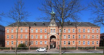
Job's Hospital
(Bürgerweide 25)
built in 1505 as a “Pockenhus” for people suffering from syphilis , converted into a residential building in 1824, originally on Spitalerstraße , since 1883/84 at the current location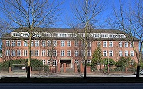
Sankt-Ansgar-Schule
(Bürgerweide 33) built in
1953 on the foundations of a former elementary school that was destroyed in World War II
St. Gertrud-Stift
(Bürgerweide 41–45)
Founded in 1454, at its present location since 1883/84 and today part of the Hartwig-Hesse Foundation


Individual evidence
- ↑ Map of the average daily vehicle traffic volume on working days (Monday – Friday), Hamburg 2013. (PDF; 5.3 MB) Retrieved on May 29, 2020 .
- ↑ Statistics Office North: Street and area directory of the Free and Hanseatic City of Hamburg (8th edition 2019), accessed on May 29, 2020.
- ↑ Horst Beckershaus: The Hamburg street names. Where do they come from and what they mean, Europäische Verlagsanstalt Hamburg 2011, p. 68.
- ^ Horst Beckershaus: The names of the Hamburg districts. Where they come from and what they mean , Ernst Kabel Verlag Hamburg 1998, p. 26.
- ↑ Michael Eissenhauer : The Hamburg Housing Foundations of the 19th Century, Christians Verlag Hamburg 1987.
- ↑ Hartwig Hesse Foundation - Cared for life! Retrieved May 29, 2020 .