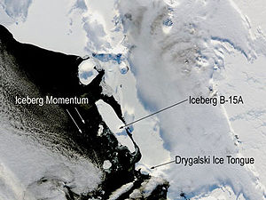
B-15
B-15 is an iceberg that broke off the Ross Ice Shelf in Antarctica in 2000 and broke into several pieces in 2002.
Emergence
In March 2000, iceberg B-15 broke off the Ross Ice Shelf and then drifted north out to sea. Its area was initially about 11,600 km² (about the size of Jamaica ). By ' calving ' B-15 , the Ross Ice Shelf returned to the size of 1911 when it was first measured by Robert Falcon Scott . The name B-15 was given by the US National Ice Center , which tracks the course of all icebergs longer than 10 nautical miles (18.5 km). B denotes icebergs in the second quadrant between 90 degrees and 180 degrees west longitude, which are then numbered in ascending order. B-15 is therefore the 15th large iceberg recorded in the second quadrant.
McMurdo Sound
Iceberg B-15 blocked McMurdo Sound , which is adjacent to the Ross Ice Shelf along the Transantarctic Mountains , so that the sound became more icy due to the changed currents. The Adelie penguin colony living there suffered a considerable decline in population because of the longer distances to the sea .
Collisions and splits
In November 2002, the B-15 broke into several pieces. The resulting fragment B-15 A was initially around 122 kilometers in length and around 27 kilometers in width and with an area of 3,100 km² even somewhat larger than the area of Luxembourg and thus the largest free-swimming natural object in the ocean . It collided with the Drygalski ice tongue , also shown in atlases and maps , from which a piece broke off as a result of this impact, which can be seen in the picture below the iceberg floating in the sea. After that, the B-15A was on a collision course with the Aviator Glacier . When the B-15A ran aground at Cape Adare on Viktorialand , it broke into several small pieces on October 27th and 28th, 2005, the largest of which are called the B-15M, B-15N and B-15P.
The course of the original fragment is followed, among other things, with a permanently installed GPS receiver. At the end of 2009, parts of the iceberg were still on the move.
On February 11, 2010, the B-15 K collided with the edge of the ice shelf near the German research station Neumayer Station III . This collision was recorded by the research station's sonar system.
Astronauts on the ISS observed the iceberg in May 2018 when it was 150 nautical miles northwest of the South Georgian Islands . At this point, a crack had formed the length of the iceberg.
See also
Web links
Individual evidence
- ^ Current Antarctic Iceberg Positions. (No longer available online.) National Ice Center , December 20, 2009, archived from the original on December 18, 2009 ; Retrieved December 20, 2009 . Info: The archive link was inserted automatically and has not yet been checked. Please check the original and archive link according to the instructions and then remove this notice.
- ↑ Antarctica: gigantic ice surface is falling apart. DER SPIEGEL , March 19, 2002, accessed December 20, 2009 .
- ↑ Iceberg rams ice shelf in front of Neumayer Station III. Press release of the Alfred Wegener Institute for Polar and Marine Research, February 22, 2010, accessed on February 22, 2010 .
- ↑ Audio stream (mp3) of the collision. (MP3; 721 kB) (No longer available online.) Alfred Wegener Institute for Polar and Marine Research, February 11, 2010, archived from the original on May 21, 2011 ; Retrieved February 22, 2010 . Info: The archive link was inserted automatically and has not yet been checked. Please check the original and archive link according to the instructions and then remove this notice.
- ↑ Viewing May 2018 , report on earthobservatory.nasa.gov dated June 6, 2018, page in English, accessed on June 6, 2018


