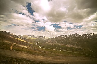
Babusar pass
| Babusar pass | |||
|---|---|---|---|
|
Babusar pass |
|||
| Compass direction | north | south | |
| Pass height | 4173 m | ||
| region | Gilgit-Baltistan autonomous region | Khyber Pakhtunkhwa Province | |
| Watershed | Thak | Kunhar | |
| Valley locations | Babusar | Gittidas | |
| expansion | unpaved slope | ||
| Mountains | Himalayas | ||
| map | |||
|
|
|||
| Coordinates | 35 ° 9 ′ 0 ″ N , 74 ° 3 ′ 0 ″ E | ||
The Babusar Pass or Babusar Top with a summit height of 4173 m above sea level is a high mountain pass in the north of Pakistan .
It connects the Diamir district in Gilgit-Baltistan in the north with the Kohistan district in Khyber Pakhtunkhwa . The pass is located at the northern end of the 150 km long Kaghan Valley . From the north side of the pass, the Thak River flows north to the Indus Valley . From the village of Babusar a slope leads to Chilas. This road reaches the Karakoram Highway 3 km from Chilas . The pass is passable from mid-July to September and not passable during monsoons and in winter. The Kaghan Valley is accessible from the cities of Balakot , Abbottabad and Mansehra .
The pass lies in the northwestern foothills of the Himalayas . The ridge on which the pass is located rises in the east about 50 km from the 8125 meter high Nanga Parbat .
Web link
Individual evidence
- ↑ Information on lonleyplanet.com ( Memento of the original from July 14, 2010 in the Internet Archive ) Info: The archive link was inserted automatically and has not yet been checked. Please check the original and archive link according to the instructions and then remove this notice. , accessed December 31, 2009


