
Bacalar
| Bacalar | ||
|---|---|---|
|
Coordinates: 18 ° 41 ′ N , 88 ° 24 ′ W Bacalar on the map of Quintana Roo
|
||
| Basic data | ||
| Country | Mexico | |
| State | Quintana Roo | |
| Municipio | Bacalar | |
| City foundation | 1545 | |
| Residents | 11,048 (2010) | |
| Detailed data | ||
| height | 20 m | |
| Post Code | 77930 | |
| prefix | 983 | |
| Time zone | UTC -5 | |
| Website | ||

Bacalar ( Mayathan Bakhalal : surrounded by reeds) is a city in the Mexican state of Quintana Roo on the Yucatán peninsula , about 40 km north of the capital Chetumal .
Bacalar was awarded as a so-called Pueblo Mágico (magical place) by SECTUR (Secretariat for Tourism in Mexico).
history
Bacalar was already a city in pre-Columbian times and the first in this region to be conquered by Spanish conquistadores in 1543 .
geography
The city is located on the west bank of the Bacalar lagoon of the same name (Laguna de Bacalar).
Web links
Commons : Bacalar - collection of images, videos and audio files
- Municipio de Bacalar , official website of the Municipios of Bacalar (Spanish)
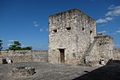
San Felipe Fortress

Bacalar Lagoon
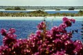
Bacalar Lagoon


