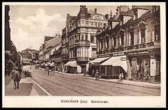
Bahnhofstrasse (Neunkirchen, Saar)
| Bahnhofstrasse | |
|---|---|
| Street in Neunkirchen (Saar) | |
| Postcard motif, ca.1913 | |
| Basic data | |
| place | Neunkirchen (Saar) |
| District | Downtown |
| Hist. Names | Binger Street; Adolf-Hitler-Strasse |
| Connecting roads | Kuchenbergstrasse (north), Gustav-Regulator-Strasse (west) |
| Cross streets | On the steep mountain, Wellesweilerstrasse, Wilhelmstrasse, Lindenallee |
| Places | Station forecourt |
| Buildings | Neunkirchen (Saar) central station , former main post office, Corona high-rise |
| Technical specifications | |
| Street length | 700 m |
The Bahnhofstrasse in Neunkirchen (Saar) is one of the main roads in Neunkirchen and part of a historical Provinzialstraße , of Bingen about Ottweiler according Saarbrücken led. The street between the Lindenallee at the height of the Stummplatz and the Konrad-Adenauer-Brücke over the railway line Homburg-Neunkirchen at the main train station bears its name .
history
Bahnhofstrasse was initially known as Binger Strasse. As a provincial road, it not only led from Saarbrücken to Bad Kreuznach , but also beyond to Bingen. When the Pfalzbahn was built, the road passed at the same height as the rails. Accordingly, the street was renamed Bahnhofstraße. In 1860, when the Rhein-Nahe-Bahn was established, Neunkirchen received a new train station, which is still in the same location today: the Neunkirchen (Saar) Hauptbahnhof . Neunkirchen became a railway junction, making the regulation with barriers accordingly impractical. Initially, an underpass was planned, but it failed. Instead, a bridge was set up (today: Konrad-Adenauer-Brücke). This connects the Kuchenbergstraße coming from Wiebelskirchen with the Bahnhofstraße. At the station itself, the station square (formerly: Am Bahnhof) was built, which can be reached via a ramp from the bridge.
Thanks to the railway, Bahnhofstrasse quickly developed into a flourishing shopping and business street. On July 9, 1907, Bahnhofstrasse was given a sidewalk and on September 28, 1911 cement slabs were used.
After the Saar referendum , the Saar area fell to the German Empire . At the end of January 1935, the city council decided to rename some streets to take into account the new political situation. The Bahnhofstrasse was given the name Adolf-Hitler-Strasse , named after Adolf Hitler , the dictator of the German Reich. At the end of the Second World War, Bahnhofstrasse, like large parts of the city center, was badly damaged by Allied bombing . It was given its old name back shortly after the surrender. The reconstruction turned out to be lengthy, as the avenue of lime trees was first renewed and the Blies straightened in order to eliminate the acute risk of flooding. The Corona high-rise was built on the corner of Lindenallee and Bahnhofstrasse.
With its restoration, Bahnhofstrasse and Hüttenbergstrasse regained their role as the main shopping street. In the 1980s this was increasingly displaced, first by the Bliespromenade, then by the Saarpark-Center shopping center . Instead, the red light district mainly expanded into the upper part of the street. A process of upgrading began in the early 1990s, but has not yet been completed. A large-scale senior citizens' residence , which will contain 50 apartments and 99 care apartments, will contribute to the upgrade .
Attractions
- Neunkirchen (Saar) Central Station with Bahnhofplatz
- Former main post office: Neunkirchen received its first post office in 1874. In 1880 the post was first moved to the upper Bahnhofstrasse and then in 1901 to the lower Bahnhofstrasse. the building was destroyed in World War II and reopened in 1951. The post office moved to Brückenstrasse in the 1970s. Today the former main post office houses some business and office space.
- Corona high-rise: The 9-storey high-rise was built in the mid-1950s.
- Stumbling blocks : Fanny, Johanna and Siegfried Günzburger (Bahnhofstraße 25), Fanny Herold (Bahnhofstraße 45)
literature
- Armin Schlicker: Street Lexicon Neunkirchen. Streets, squares and bridges in the past and present . Published by Historischer Verein Stadt Neunkirchen eV Neunkirchen 2009. ISBN 978-3-00-027592-0 . Pp. 53-57
Individual evidence
- ↑ Google Maps
- ^ Armin Schlicker: Street Lexicon Neunkirchen. Streets, squares and bridges in the past and present . Published by Historischer Verein Stadt Neunkirchen eV Neunkirchen 2009. ISBN 978-3-00-027592-0 . P. 53
- ^ Neunkirchen: New building of a senior citizens' residence - assisted living and care. (No longer available online.) IFA Real Estate, archived from the original on May 29, 2015 ; accessed on May 23, 2015 . Info: The archive link was inserted automatically and has not yet been checked. Please check the original and archive link according to the instructions and then remove this notice.

