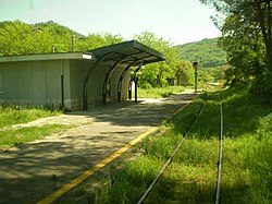
Avellino – Rocchetta Sant'Antonio railway line
| Avellino-Rocchetta Sant'Antonio | |||||||||||||||||||||||||||||||||||||||||||||||||||||||||||||||||||||||||||||||||||||||||||||||||||||||||||||||||||||||||||||||||||||||||||||||||||||||||||||
|---|---|---|---|---|---|---|---|---|---|---|---|---|---|---|---|---|---|---|---|---|---|---|---|---|---|---|---|---|---|---|---|---|---|---|---|---|---|---|---|---|---|---|---|---|---|---|---|---|---|---|---|---|---|---|---|---|---|---|---|---|---|---|---|---|---|---|---|---|---|---|---|---|---|---|---|---|---|---|---|---|---|---|---|---|---|---|---|---|---|---|---|---|---|---|---|---|---|---|---|---|---|---|---|---|---|---|---|---|---|---|---|---|---|---|---|---|---|---|---|---|---|---|---|---|---|---|---|---|---|---|---|---|---|---|---|---|---|---|---|---|---|---|---|---|---|---|---|---|---|---|---|---|---|---|---|---|---|
|
Stop at Luogosano-San Mango sul Calore
| |||||||||||||||||||||||||||||||||||||||||||||||||||||||||||||||||||||||||||||||||||||||||||||||||||||||||||||||||||||||||||||||||||||||||||||||||||||||||||||
| Route number (RFI) : | 128 | ||||||||||||||||||||||||||||||||||||||||||||||||||||||||||||||||||||||||||||||||||||||||||||||||||||||||||||||||||||||||||||||||||||||||||||||||||||||||||||
| Course book series (IT) : | 335 | ||||||||||||||||||||||||||||||||||||||||||||||||||||||||||||||||||||||||||||||||||||||||||||||||||||||||||||||||||||||||||||||||||||||||||||||||||||||||||||
| Route length: | 119 km | ||||||||||||||||||||||||||||||||||||||||||||||||||||||||||||||||||||||||||||||||||||||||||||||||||||||||||||||||||||||||||||||||||||||||||||||||||||||||||||
| Gauge : | 1435 mm ( standard gauge ) | ||||||||||||||||||||||||||||||||||||||||||||||||||||||||||||||||||||||||||||||||||||||||||||||||||||||||||||||||||||||||||||||||||||||||||||||||||||||||||||
|
|||||||||||||||||||||||||||||||||||||||||||||||||||||||||||||||||||||||||||||||||||||||||||||||||||||||||||||||||||||||||||||||||||||||||||||||||||||||||||||
The Avellino – Rocchetta Sant'Antonio railway runs through the Italian regions of Campania , Basilicata and Apulia . It connects the provincial capital Avellino with the interior.
The railway line was opened to traffic in three sections between 1892 and 1895 and is around 120 kilometers long, single-track and not electrified.
It runs from Avellino in a north-easterly direction and after 20 kilometers follows the Calore river to Montella . The route then looks for its way east into the interior of the country and follows the Ofanto river valley from Lioni . From Cairano the railway line and the river runs along the border with the Basilicata region and reaches the Apulia region about 3 kilometers before the end. Most of the stations are far away from the namesake locations. In 2010 there was only regional traffic. A trip on the route took 2:39 hours. Passenger traffic was discontinued when the timetable changed in December 2010. The route was incorporated into a law on tourist railways on August 2, 2017, and on August 25, 2017 the first train ran between Rocchetta Sant'Antonio-Lacedonia and Lioni.
| section | release | Length (km) |
|---|---|---|
| Monteverde-Rocchetta Sant'Antonio | March 29, 1892 | 13,870 |
| Avellino – Paternopoli | October 27, 1893 | 26,709 |
| Paternopoli – Monteverde | October 27, 1895 | 78.150 |
Individual evidence
- ↑ Chronological listing of the opening of sections of the Italian railway from 1839 to December 31, 1926 ( Italian ) Trenidicarta.it. Retrieved September 10, 2010.
- ^ Website of the Italian railway company Ferrovie dello stato.it ( Italian ) Trenidicarta.it. Retrieved September 10, 2010.
- ↑ Italy: Claudia Cardinale re-opens the Rocchetta-Lacedonia - Avellino railway line , LOK report, 23 August 2017, accessed on 25 August 2017
- ↑ Sponzfest Express , Fondazione FS Italiane, accessed on August 25, 2017
- ↑ Chronological listing of the opening of sections of the Italian railway from 1839 to December 31, 1926 ( Italian ) Trenidicarta.it. Retrieved September 10, 2010.
