Baird (Texas)
| Baird | |
|---|---|
 Buildings in downtown Baird Texas |
|
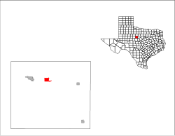
| Location of Baird, Texas | |
| Basic data | |
| Foundation : | 1881 |
| State : | United States |
| State : | Texas |
| County : | Callahan County |
| Coordinates : | 32 ° 24 ′ N , 99 ° 24 ′ W |
| Time zone : | Central ( UTC − 6 / −5 ) |
| Residents : | 1,623 (as of: 2000) |
| Population density : | 238.7 inhabitants per km 2 |
| Area : | 7.0 km 2 (approx. 3 mi 2 ) of which 6.8 km 2 (approx. 3 mi 2 ) is land |
| Height : | 570 m |
| Postal code : | 79504 |
| Area code : | +1 915 |
| FIPS : | 48-05336 |
| GNIS ID : | 1372371 |
| Website : | www.bairdtexas.com |
 Baird Main Street |
|
Baird is a place and seat of the county seat of Callahan County in the US state of Texas in the United States .
geography
The city is located north of the geographic center of Texas on Interstate 20 and US Highway 283 , about 230 kilometers west of Dallas and has a total area of 7 km², of which 0.2 km² is water.
history
In 1880 the former railway camp of the Texas & Pacific Railway became a permanent settlement. It was named on December 14, 1880 after Matthew Baird, the owner and director of the railway company. On January 16, 1883, she was elected the district capital. On June 22, 1993, the town was awarded the title Antique Capital of West Texas .
Demographics
The average income of a household is 27,446 USD , the average income of a family at $ 35,000. Men have a median income of $ 21,974 versus women averaging $ 16,298. The per capita income is $ 13,951. 14.0% of the population and 12.3% of families live below the poverty line.
23.4% of the population are under 18 years old and for every 100 women aged 18 and over there are 88.9 men. The average age is 41 years. (Status: 2000).
Web links
- Handbook of Texas (Engl.)
