Bakenberg (Hiddensee)
| Bakenberg | ||
|---|---|---|
|
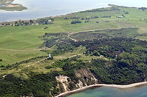
The Bakenberg in the right part of the picture |
||
| height | 72.5 m above sea level NHN | |
| location | Hiddensee , Mecklenburg-Western Pomerania , Germany | |
| Coordinates | 54 ° 35 '50 " N , 13 ° 7' 1" E | |
|
|
||
The Bakenberg is about 72.7 m above sea level. NHN the highest point on the island of Hiddensee in Mecklenburg-Western Pomerania . It is located on the Dornbusch ridge in the north of the island, a little south of the Dornbusch lighthouse of the same name . This is located on the second highest elevation on the island, the approximately 70 meter high Schluckswiek or Schluckwieksberg . To the south of the mountain is the village of Kloster .
To the west of the elevation is the Svantevit Gorge, which slopes steeply to the Baltic Sea. The Bakenberg is forested.
The formation of the Dornbusches highlands and thus also of the Bakenberg goes back to the last phase of glaciation in northern Germany, the Vistula Ice Age around 12,500 years ago. When the glaciers retreated, it remained as a compression moraine and was part of a large mainland area in the south of today's Baltic Sea for about 4000 years. During the first flooding phase of the Baltic Sea, the water did not yet reach the area around Hiddensee, only about 3900 years ago did the Lithorina Sea wash around the three island cores Dornbusch, Fährinsel and Gellen. Coastal erosion (land erosion, drifting and sedimentation) and the formation of the elongated shape of Hiddensee through sand alluvial only began 2900 years ago.
The elevation consists mainly of alternating layers of clay till, sand, gravel and writing chalk.
The mountain is in the Vorpommersche Boddenlandschaft National Park and in the Dornbusch and Schwedenhagener Ufer nature reserve .
See also
Individual evidence
- ↑ Map services of the Federal Agency for Nature Conservation ( information )
- ↑ Topographic map 1: 25,000 1444 Vitte
- ↑ Birgit Toussaint, Frank Toussaint, Matthias Hünsch: Lighthouses on the German Baltic coast. Edition Maritim, 2009, ISBN 978-3-89225-616-8 .

