Barajevska reka
|
Barajevska reka Barajevica |
||
|
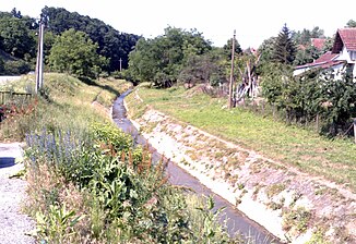
The Barajevska reka in Barajevo |
||
| Data | ||
| location | Central Serbia | |
| River system | Danube | |
| Drain over | Beljanica → Kolubara → Save → Danube → Black Sea | |
| origin | Confluence of Krčevica and Rakovica when Weiler Nenadovac 44 ° 36 '29 " N , 20 ° 25' 50" O |
|
| muzzle | In the Beljanica the village Beljina coordinates: 44 ° 31 '0 " N , 20 ° 21' 55" O 44 ° 31 '0 " N , 20 ° 21' 55" O
|
|
| length | 12.7 km | |
| Catchment area | 77 km² | |
| Communities | Barajevo | |
| Ports | no | |
| Navigable | No | |
The Barajevska reka ( Serbian Cyrillic : Барајевска река) or Barajevica is a river in the Belgrade municipality of Barajevo in Serbia . The total length of the river is 12.7 km and the catchment area is approx. 77 km².
River course
The Barajevska reka is created by the confluence of the two streams Krčevica and Rakovica , near the hamlet of Nenadovac northeast of the settlement of Barajevo. About 30 km south of Belgrade city center.
Moving from the hamlet of Nenadovac to the southwest, it flows through the center of Barajevo, past the Church of the Burning of the Relics of St. Sava .
It flows further south, leaves Barajevo and reaches the area of the village Boždarevac . It crosses the center of the village and continues to flow in a south-westerly direction to the eastern part of the village of Veliki Borak . Shortly after leaving the village of Veliki Borak, it flows west of the center of Beljina into the Beljanica , a right tributary of the Kolubara . It is not navigable.
source
- Nada Jovanović: Barajevski prostori nekad i sad , Beograd, 2000.
