Bavarian ring
| Bavarian ring | |
|---|---|
| Street in Munich | |
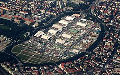
| Bavariaring is the eastern curved part of the ring road around Theresienwiese | |
| Basic data | |
| State capital | Munich |
| Townships | Ludwigsvorstadt-Isarvorstadt , Schwanthalerhöhe |
| Name received | around 1887 |
| Connecting roads | Martin-Greif-Straße, Theresienhöhe, Bavariastraße |
| Cross streets | Schwanthalerstraße , Sankt-Pauls-Platz, Pettenkoferstraße, Uhlandstraße, Rückertstraße, Beethovenstraße, Schubertstraße, Mozartstraße, Kobellstraße, Matthias-Pschorr-Straße, Hermann-Schmid-Straße, Stielerstraße, Güllstraße, Poccistraße, Hans-Fischer-Straße |
| Places | Sankt-Pauls-Platz |
| Numbering system | consecutive numbering on one side |
| Subway | U 4, U 5 underground station Theresienwiese |
| use | |
| User groups | Pedestrian traffic , bicycle traffic , individual traffic , public transport |
| Road design | Asphalt, mostly lined with avenue trees |
| Technical specifications | |
| Street length | 1.5 km |
The Bavariaring is an approx. 1450 m long inner-city street in the Munich district of Ludwigsvorstadt-Isarvorstadt . Together with the Theresienhöhe to the west, it borders the Theresienwiese . The monumental statue of Bavaria was the origin for the naming around 1887.
description
At Bavariaring 5 is the public lavatory at Bavariaring , at Bavariaring 37 is the Bavarian Teachers Association , at Bavariaring 46 is the Maria Theresia Clinic . The Theresienwiese underground station is at the Bavariaring . The Reich Office for Agricultural Policy was located at Bavariaring No. 21 .
There are 26 listed buildings on Bavariaring, see also: List of architectural monuments in Ludwigsvorstadt .
Web links
Commons : Bavariaring - collection of images, videos and audio files
Individual evidence
- ^ A b Hans Dollinger: The Munich street names. 5th edition. Ludwig Verlag, Munich 2004, ISBN 3-7787-5174-3
Coordinates: 48 ° 7 ′ 48.6 ″ N , 11 ° 33 ′ 11.8 ″ E

