Beaufort Island
| Beaufort Island | ||
|---|---|---|
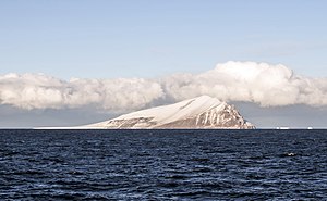
| The Beaufort Island with an iceberg | ||
| Waters | Ross Sea | |
| Archipelago | Ross Archipelago | |
| Geographical location | 76 ° 57 ′ 0 ″ S , 166 ° 57 ′ 0 ″ E | |
|
|
||
| length | 5.5 km | |
| width | 2.7 km | |
| surface | 11.3 km² | |
| Highest elevation |
Paton Peak 740 m |
|
| Residents | uninhabited | |
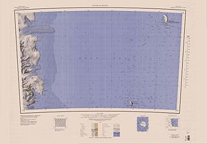
| Beaufort Island in the southeastern part of the map sheet | ||
The Beaufort Island is the northernmost island of the Ross Archipelago in the Antarctic Ross Sea .
geography
Beaufort Island is about 22 kilometers north of Ross Island and 100 kilometers south of Franklin Island . It is 5.5 km long and 2.7 km wide. Its highest point is at 740 m (according to New Zealand information 771 m ) the Paton Peak . Beaufort Island is the remnant of an eroded volcanic crater . Most of it is glaciated. Where the snow melts in summer, shallow ponds are created. Beaufort Island and the parts of the former volcanic cone that lie below sea level represent a natural obstacle to the predominantly westward drifting pack ice , which promotes the formation of fast ice . The icebergs breaking from the Ross Ice Shelf also run aground here.
fauna and Flora
The Beaufort Island has the most species-rich bird life in the area of the southern Ross Sea. A colony of Adelie penguins , which has consisted of around 39,000 pairs on average over many years and which grew to over 70,000 breeding pairs by 2013/2014, is located on Cadwalader Beach in the southwest of the island and has existed for 45,000 years. A second colony on the north coast was first sighted in 1995 and had grown to 989 pairs by 2013/2014. An estimated 1,600 pairs of the emperor penguins breed on the fast ice on the northwest coast. In addition, two colonies and some pairs of snow petrels breed on the island of Antarctica .
Weddell seals raise their young on the fast ice off the island's coast. In the adjacent waters there are leopard seals , crab eaters , killer whales , minke whales and black whales .
The vegetation is very sparse, only at the foot of the Skua colony in the north of the island is there an area that is densely overgrown with the moss Bryum subrotundifolium . There are more mosses and algae scattered around , but no lichens .
environmental Protection
To protect the fauna, the Beaufort Island is designated as a specially protected area of Antarctica No. 105 ( Antarctic Specially Protected Area No. 105 ) and may not be entered without permission.
BirdLife International designates the Beaufort Island as an Important Bird Area (AQ188).
history
The island was in 1841 by James Clark Ross mapped and to Francis Beaufort , the Hydrographer of the Royal Navy named.
Web links
- Beaufort Island in the Geographic Names Information System of the United States Geological Survey .
- Beaufort Island in the Global Volcanism Program of the Smithsonian Institution (English).
Individual evidence
- ↑ a b c d Beaufort Island, McMurdo Sound, Ross Sea , Management Plan for Antarctic Specially Protected Area No. 105, accessed on August 24, 2017 (PDF; 2.06 MB, English)
- ↑ Rodney D. Seppelt, TGA Green, M. Skotnicki: Notes on the Flora, Vertebrate Fauna and Biological Significance of Beaufort Island, Ross Sea, Antarctica (PDF; 989 kB). In: Polarforschung 66, No. 1-2, 1996 (published 1999), pp. 53-59 (English).
- ↑ Beaufort Island (AQ188) , datasheet on the BirdLife International website, accessed July 23, 2018.


