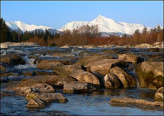
Belá (river)
| Belá | ||
| Data | ||
| location | Slovakia | |
| Drain over | Waag → Danube → Black Sea | |
| origin |
High Tatras 49 ° 9 ′ 19 ″ N , 19 ° 55 ′ 22 ″ E |
|
| Source height | 976 m nm | |
| muzzle |
Waag in Liptovský Hrádok Coordinates: 49 ° 2 ′ 6 " N , 19 ° 42 ′ 37" E 49 ° 2 ′ 6 " N , 19 ° 42 ′ 37" E |
|
| Mouth height | 629 m nm | |
| Height difference | 347 m | |
| Bottom slope | 16 ‰ | |
| length | 22 km | |
| Catchment area | 244 km² | |
| Drain |
MQ |
3.48 m³ / s |
The Belá (German white water ) is a 22 kilometer long tributary of the Waag in northern Slovakia . It rises through the confluence of the Tichý potok (Stillbach) and Kôprovský potok in the High Tatras near Podbanské , a district of the city of Vysoké Tatry and then flows through the Liptov basin to the confluence with the Waag near Liptovský Hrádok .
See also
Web links
Commons : Belá - collection of images, videos and audio files
