Belgrove (New Zealand)
| Belgrove | ||
| Geographical location | ||
|
|
||
| Coordinates | 41 ° 27 ′ S , 172 ° 58 ′ E | |
| Region ISO | NZ-TAS | |
| Country |
|
|
| region | Tasman | |
| District | Tasman District | |
| Ward | Lakes - Murchison Ward | |
| Residents | few | |
| height | 135 m | |
| Post Code | 7095 | |
| Telephone code | +64 (0) 3 | |
| Photography of the place | ||
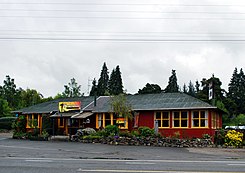
 Belgrove Inn |
||
Belgrove is a small settlement in the Tasman regionon the North Island of New Zealand .
Origin of name
The settlement was originally called Bell Grove , named after the settler James Bell , who had lived in Nelson since 1847 .
geography
The settlement is located around 34 km southwest of Nelson on New Zealand State Highway 6 . Neighboring towns on State Highway 6 are Foxhill in the northeast and Kohatu in the west. A side road connects the settlement with Hiwipango in the southwest.
Monument protection
The Belgrove Railway Windmill , built to pump water to supply steam locomotives passing through, is registered as a Category 1 Monument by the New Zealand Historic Places Trust .
Individual evidence
- ↑ Helga Neubauer: Hope . In: The New Zealand Book . 1st edition. NZ Visitor Publications , Nelson 2003, ISBN 1-877339-00-8 , pp. 1011 .
- ^ Wise Maps (ed.): New Zealand Travel Atlas . Map 47. Auckland , ISBN 0-908794-47-9 .
- ^ Belgrove Railway Windmill. Historic Place Category 1. In: New Zealand Heritage List / Rārangi Kōrero . Heritage New Zealand Pouhere Taonga , June 28, 1990, accessed September 25, 2019 .
