Barking Ker Range
| Barking Ker Range | ||
|---|---|---|
|
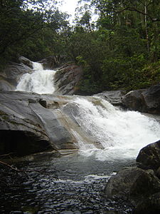
Josephine Falls |
||
| Highest peak | Mount Bartle Frere ( 1622 m ) | |
| location | Queensland | |
|
|
||
| Coordinates | 17 ° 14 ′ S , 145 ° 52 ′ E | |
| rock | granite | |
The Bellenden Ker Range (German: Bellenden-Ker-Bergland ), also known as the Wooroonooran Range , is a coastal mountain country in northern Queensland in Australia .
It is part of the Great Dividing Range and extends approximately 65 km between Gordonvale and Nerada in the south of Cairns .
description
The mountainous country consists of a granite massif and is part of the Wet Tropics World Heritage Area . Abundant and biodiverse forests of a protected rainforest listed as a UNESCO World Heritage site predominate, containing valuable endemic flora and fauna, with most of the high quality protected species located in Wooroonooran National Park.
The two highest mountains in Queensland, Mount Bartle Frere (1,622 m) and Mount Bellenden Ker (1,593 m), are located in this mountainous area, as is Walsh's Pyramid (922 m), a large, naturally formed, pyramidal mountain in the north of the Berglands.
history
The mountains were sighted by Lieutenant James Cook , but they were not given the name "Bellenden Ker Range", instead Lieutenant Phillip Parker King saw them on June 22, 1819 when he saw them aboard the HMCC Mermaid . Phillip King named the mountains after the British botanist John Bellenden Ker Gawler when he followed a suggestion by the botanist Allan Cunningham on the ship, and Archibald Meston was also an early discoverer of these mountains.
Tourism, rivers and rainfall
The Mulgrave River flows along the mountains to the southwest, then turns north around the end of the mountains, turns further south and flows parallel along the east side of the mountains. The Russell River drains the southeastern areas.
It is one of the rainiest areas in Australia. The weather station on Mount Bellenden Ker measured an annual rainfall of 12,438 m in 2010, which was the highest amount of rainfall per year that was ever measured in Queensland.
A number of waterfalls can be found in the mountains. In addition to the national parks, Josephine Falls and the hiking trails to Mount Bartle Frere are popular tourist destinations.
Individual evidence
- ^ The Mulgrave River , Gallery of satellite images , Queensland Government, accessed April 8, 2015
- ↑ wettropics.gov.au ( Memento of the original from September 12, 2009 in the Internet Archive ) Info: The archive link was automatically inserted and not yet checked. Please check the original and archive link according to the instructions and then remove this notice. : Wet Tropics Management Authority World Heritage Area maps, accessed October 9, 2011
- ↑ cairns.qld.gov.au : Cairns Heritage: B Suburbs , in English, accessed April 7, 2015
- ↑ bom.gov.au : Bureau of Meteorology: Climate Summary for Queensland , in English, accessed October 9, 2011
- ↑ summitpost.org : Bellenden Ker Range , in English, accessed October 9, 2011

